
 | ||
Foreland basin
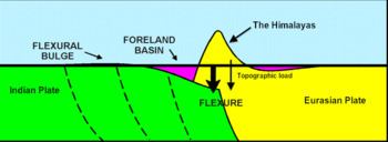
A foreland basin is a structural basin that develops adjacent and parallel to a mountain belt. Foreland basins form because the immense mass created by crustal thickening associated with the evolution of a mountain belt causes the lithosphere to bend, by a process known as lithospheric flexure. The width and depth of the foreland basin is determined by the flexural rigidity of the underlying lithosphere, and the characteristics of the mountain belt. The foreland basin receives sediment that is eroded off the adjacent mountain belt, filling with thick sedimentary successions that thin away from the mountain belt. Foreland basins represent an endmember basin type, the other being rift basins. Space for sediments (accommodation space) is provided by loading and downflexure to form foreland basins, in contrast to rift basins, where accommodation space is generated by lithospheric extension.
Contents
- Foreland basin
- Sistemas de bacias de foreland foreland basin systems
- Types of foreland basin
- Foreland basin system
- Foreland basin systems depozones
- Plate motion and seismicity
- Formation of basins
- Lithospheric behavior
- Lithospheric strength envelopes
- Thermal history
- Fluid migration
- Fluid source
- Major driving force for fluid migration
- Hydrocarbon migration
- Europe
- Asia
- Middle East
- North America
- South America
- References
Sistemas de bacias de foreland foreland basin systems
Types of foreland basin
Foreland basins can be divided into two categories:
Foreland basin system
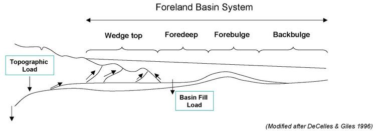
DeCelles & Giles (1996) provide a thorough definition of the foreland basin system. Foreland basin systems comprise three characteristic properties:
- An elongate region of potential sediment accommodation that forms on continental crust between a contractional orogenic belt and the adjacent craton, mainly in response to geodynamic processes related to subduction and the resulting peripheral or retroarc fold-thrust belt;
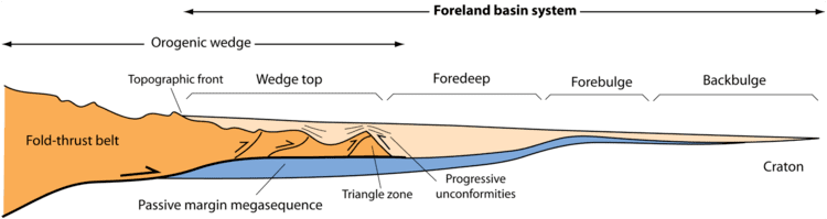
- It consists of four discrete depozones, referred to as the wedge-top, foredeep, forebulge and back-bulge depozones (depositional zones) – which of these depozones a sediment particle occupies depends on its location at the time of deposition, rather than its ultimate geometric relationship with the thrust belt;
- The longitudinal dimension of the foreland basin system is roughly equal to the length of the fold-thrust belt, and does not include sediment that spills into remnant ocean basins or continental rifts (impactogens).
Foreland basin systems: depozones
The wedge-top sits on top of the moving thrust sheets and contains all the sediments charging from the active tectonic thrust wedge. This is where piggyback basins form.
The foredeep is the thickest sedimentary zone and thickens toward the orogen. Sediments are deposited via distal fluvial, lacustrine, deltaic, and marine depositional systems.
The forebulge and backbulge are the thinnest and most distal zones and are not always present. When present, they are defined by regional unconformities as well as aeolian and shallow-marine deposits.
Sedimentation is most rapid near the moving thrust sheet. Sediment transport within the foredeep is generally parallel to the strike of the thrust fault and basin axis.
Plate motion and seismicity
The motion of the adjacent plates of the foreland basin can be determined by studying the active deformation zone with which it is connected. Today GPS measurements provide the rate at which one plate is moving relative to another. It is also important to consider that present day kinematics are unlikely to be the same as when deformation began. Thus, it is crucial to consider non-GPS models to determine the long-term evolution of continental collisions and in how it helped develop the adjacent foreland basins.
Comparing both modern GPS (Sella et al. 2002) and non-GPS models allows deformation rates to be calculated. Comparing these numbers to the geologic regime helps constrain the number of probable models as well as which model is more geologically accurate within a specific region.
Seismicity determines where active zones of seismic activity occur as well as measure the total fault displacements and the timing of the onset of deformation (Allen et al. 2004).
Formation of basins
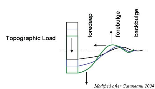
Foreland basins form because as the mountain belt grows, it exerts a significant mass on the Earth’s crust, which causes it to bend, or flex, downwards. This occurs so that the weight of the mountain belt can be compensated by isostasy at the upflex of the forebulge.
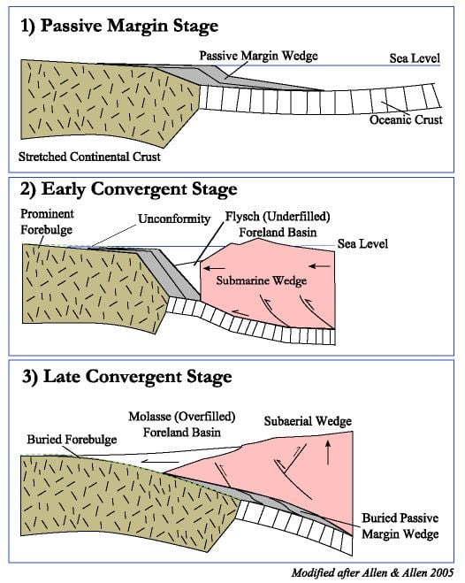
The plate tectonic evolution of a peripheral foreland basin involves three general stages. First, the Passive margin stage with orogenic loading of previously stretched continental margin during the early stages of convergence. Second, the "early convergence stage defined by deep water conditions", and lastly a "later convergent stage during which a subaerial wedge is flanked with terrestrial or shallow marine foreland basins" (Allen & Allen 2005).
The temperature underneath the orogen is much higher and weakens the lithosphere. Thus, the thrust belt is mobile and the foreland basin system becomes deformed over time. Syntectonic unconformities demonstrate simultaneous subsidence and tectonic activity.
Foreland basins are filled with sediments which erode from the adjacent mountain belt. In the early stages, the foreland basin is said to be underfilled. During this stage, deep water and commonly marine sediments, known as flysch, are deposited. Eventually, the basin becomes completely filled. At this point, the basin enters the overfilled stage and deposition of terrestrial clastic sediments occurs. These are known as molasse. Sediment fill within the foredeep acts as an additional load on the continental lithosphere.
Lithospheric behavior
Although the degree to which the lithosphere relaxes over time is still controversial, most workers (Allen & Allen 2005, Flemings & Jordan 1989) accept an elastic or visco-elastic rheology to describe the lithospheric deformation of the foreland basin. Allen & Allen (2005) describe a moving load system, one in which the deflection moves as a wave through the foreland plate before the load system. The deflection shape is commonly described as an asymmetrical low close to the load along the foreland and a broader uplifted deflection along the forebulge. The transport rate or flux of erosion, as well as sedimentation, is a function of topographic relief.
For the loading model, the lithosphere is initially stiff, with the basin broad and shallow. Relaxation of the lithosphere allows subsidence near the thrust, narrowing of basin, forebulge toward thrust. During times of thrusting, the lithosphere is stiff and the forebulge broadens. The timing of the thrust deformation is opposite that of the relaxing of the lithosphere. The bending of the lithosphere under the orogenic load controls the drainage pattern of the foreland basin. The flexural tilting of the basin and the sediment supply from the orogen.
Lithospheric strength envelopes
Strength envelopes indicate that the rheological structure of the lithosphere underneath the foreland and the orogen are very different. The foreland basin typically shows a thermal and rheological structure similar to a rifted continental margin with three brittle layers above three ductile layers. The temperature underneath the orogen is much higher and thus greatly weakens the lithosphere. According to Zhou et al. (2003), “under compressional stress the lithosphere beneath the mountain range becomes ductile almost entirely, except a thin (about 6 km in the center) brittle layer near the surface and perhaps a thin brittle layer in the uppermost mantle.” This lithospheric weakening underneath the orogenic belt may in part cause the regional lithospheric flexure behavior.
Thermal history
Foreland basins are considered to be hypothermal basins (cooler than normal), with low geothermal gradient and heat flow. Heat flow values average between 1 and 2 HFU (40-90 mWm−2 (Allen & Allen 2005). Rapid subsidence may be responsible for these low values.
Over time sedimentary layers become buried and lose porosity. This can be due to sediment compaction or the physical or chemical changes, such as pressure or cementation. Thermal maturation of sediments is a factor of temperature and time and occurs at shallower depths due to past heat redistribution of migrating brines.
Vitrinite reflectance, which typically demonstrates an exponential evolution of organic matter as a function of time, is the best organic indicator for thermal maturation. Studies have shown that present day thermal measurements of heat flow and geothermal gradients closely correspond to a regime’s tectonic origin and development as well as the lithospheric mechanics (Allen & Allen 2005).
Fluid migration
Migrating fluids originate from the sediments of the foreland basin and migrate in response to deformation. As a result, brine can migrate over great distances. Evidence of long-range migration includes: 1) Correlation of petroleum to distant source rocks 2) Ore bodies deposited from metal-bearing brines, 3) Anomalous thermal histories for shallow sediments, 4) Regional potassium metasomatism, 5) Epigenetic dolomite cements in ore bodies and deep aquifers (Bethke & Marshak 1990).
Fluid source
Fluids carrying heat, minerals, and petroleum, have a vast impact on the tectonic regime within the foreland basin. Before deformation, sediment layers are porous and full of fluids, such as water and hydrated minerals. Once these sediments are buried and compacted, the pores become smaller and some of the fluids, about 1/3, leave the pores. This fluid has to go somewhere. Within the foreland basin, these fluids potentially can heat and mineralize materials, as well as mix with the local hydrostatic head.
Major driving force for fluid migration
Orogen topography is the major driving force of fluid migration. The heat from the lower crust moves via conduction and groundwater advection. Local hydrothermal areas occur when deep fluid flow moves very quickly. This can also explain very high temperatures at shallow depths.
Other minor constraints include tectonic compression, thrusting, and sediment compaction. These are considered minor because they are limited by the slow rates of tectonic deformation, lithology and depositional rates, on the order of 0–10 cm yr−1, but more likely closer to 1 or less than 1 cm yr−1. Overpressured zones might allow for faster migration, when 1 kilometer or more of shaly sediments accumulate per 1 million years (Bethke & Marshak 1990).
Bethke & Marshak (1990) state that “groundwater that recharges at high elevation migrates through the subsurface in response to its high potential energy toward areas where the water table is lower.”
Hydrocarbon migration
Bethke & Marshak (1990) explain that petroleum migrates not only in response to the hydrodynamic forces that drive groundwater flow, but to the buoyancy and capillary effects of the petroleum moving through microscopic pores. Migration patterns flow away from the orogenic belt and into the cratonic interior. Frequently, natural gas is found closer to the orogen and oil is found further away (Oliver 1986).