
Settled 1800s Time zone EST (UTC−5) Population 3,312 (2011) Province Québec | RCM Le Rocher-Percé Constituted January 1, 1971 Area 550.3 km² Local time Sunday 10:47 PM | |
 | ||
Weather -6°C, Wind W at 3 km/h, 39% Humidity Points of interest | ||
Percé is a small city near the tip of the Gaspé Peninsula in Quebec, Canada. Within the territory of the city there is a village community also called Percé.
Contents
Map of Perc%C3%A9, QC, Canada
Percé, member of the association of Most Beautiful Villages of Quebec, is mainly a tourist location particularly well known for the attractions of Percé Rock and Bonaventure Island.
In addition to Percé itself, the town's territory also includes the communities of Barachois, Belle-Anse, Bougainville, Bridgeville, Cap-d'Espoir, Cannes-de-Roches, Coin-du-Banc, L'Anse-à-Beaufils, Pointe-Saint-Pierre, Rameau, Saint-Georges-de-Malbaie, and Val-d'Espoir.
Percé is the seat of the judicial district of Gaspé.
History
The area was within the traditional homelands of the Mi'kmaq people, who called the place Sigsôg ("steep rocks" or "crags") and Pelseg ("fishing place"). In 1603, Samuel de Champlain visited the area and named the famous rock Isle Percée ("Pierced Island"). During the 17th century, the place was used primarily as a stop-over for ships travelling to Quebec.
Used as a seasonal fishing centre during the New France era, permanent settlement began in the early 19th century with the arrival of Irish, French Canadian, and Jersey natives. In 1801 the Parish of Saint-Michel-de-Percé was founded. Percé became the most important fishing location on the Gaspé Peninsula after Charles Robin, a native of Jersey, began his fishing establishment. Old buildings of the Charles Robin Company can still be seen there.
In 1842, the geographic township of Percé was formed, and 3 years later, the place was incorporated as a township municipality.
In 1942, the Royal Canadian Navy made a decision to expand Direction Finding and wireless intercept at Cap D'Espoir to a 24-hour basis in order to provide more bearings on German U-boats and to intercept enemy radio traffic. The Department of Transport placed its facilities at the disposal of the RCN. On May 21/45, the Canadian Naval Service approved the closing down and disposal of Harbour Grace and Cap D'Espoir intercept stations.
In 1971, Percé was greatly expanded and gained ville (town) status when it amalgamated with these 5 surrounding municipalities (with year of original incorporation):
Tourism
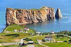
Percé Rock is a natural rock formation located close to the shore facing the town. It is a natural tourist attraction for its size, color, and unusual door-like hole at one end the rock. It can be seen from any of the belvederes in the area including Mount Joli, Mount Sainte-Anne and Pic de l'Aurore. Tourists can walk up to the hole in the rock at low tide.
Bonaventure Island occupies an area of 4.16 square km facing the town of Percé. It is populated by one of the most important gannet colonies in the world and many other species of birds such as puffins, cormorants and murres also use the island as a home and breeding ground.
Whale watching is also a popular attraction in local area, and most notably, North Atlantic right whales, one of the rarest whales, had begun to concentrate off Percé in 1995 (this species was used to be regarded as sporadic visitors into Gulf of St. Lawrence until in 1994, and gradual increases have been confirmed in entire St. Lawrence since in 1998), and Gaspe Peninsula has become the center of sightings in St. Lawrence region.
Further inland from Percé lies Mount Blanc which has a deep crevasse, as well as many other belvederes that overlook Cannes-de-Roches. Mount Sainte-Anne, with a height of 375 metres, provides views of the sea and, during times of good visibility, Miscou Island in New Brunswick can be seen.
Transportation
Percé can be accessed via Route 132, coming either from the north or the south, and by Via Rail's Montreal – Gaspé train which stops at the Percé railway station. It is also reachable by air from the nearby Du Rocher-Percé Airport via private or charter aircraft - there is no scheduled air service to this airport.
Behind the magnificent St. Michael’s Church of Perce, walking trails lead up past panoramic lookouts to the summit of Mont Saint-Anne of 348 metres (1,142 ft), the Grotto of mother mary with a beautiful waterfall and Crevasse. Another high hill, Mont-Blanc, offers a spectacular view of the region.
In the coastal waters, visitors can observe various species of marine mammals, such as seals and whales. The region is home to thousands of marine birds, which crowd the rocks of the Parc national de l’Ile-Bonaventure-et-du-Rocher-Perce facing of the town, just 2 miles off the coast of Perce.