
Existed: 1962 – present Counties: Berks Constructed 1962 | Length 17.04 km | |
 | ||
North end: PA 143 in Albany Township County | ||
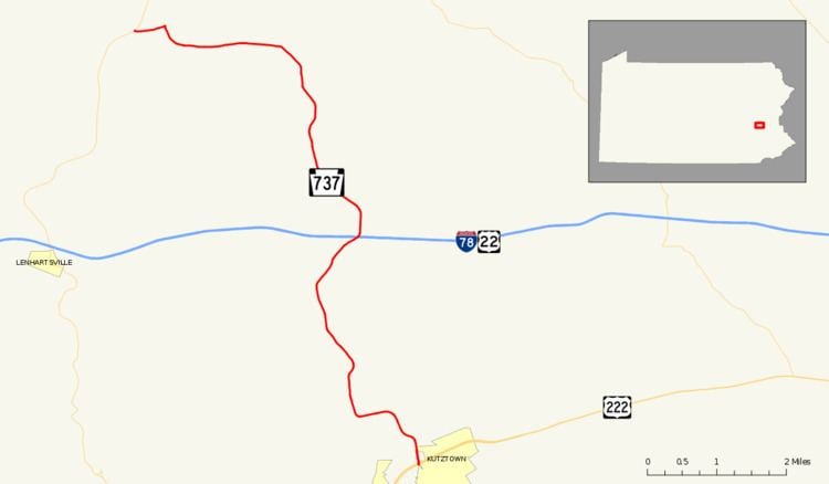
Pennsylvania Route 737 (PA 737) is a state highway in Berks County, Pennsylvania. The route runs from U.S. Route 222 (US 222) in Kutztown north to PA 143 in Albany Township. PA 737 heads north from an interchange with the US 222 Kutztown Bypass north of Kutztown on Krumsville Road. It continues north through a small part of Maxatawny Township into Greenwich Township. The road features an interchange with Interstate 78 (I-78)/US 22 near the village of Krumsville. PA 737 then heads northwest into Albany Township where it ends at PA 143 near the village of Kempton.
Contents
Map of PA-737, Pennsylvania, USA
PA 737 was assigned to a formerly un-designated local road between Kutztown and Kempton in 1962. Around that time, US 222 served as the southern terminus in downtown Kutztown. When the Kutztown Bypass was constructed in the 1970s, US 222 was realigned off of Main Street in Kutztown and onto the bypass. The road, at that point, ended at the now locally maintained Main Street until 1978, when the designation was truncated. Since then, the route has remained on the same alignment. Two bridges along the route between Kutztown and Krumsville were replaced in 2011. There are plans to reconstruct the interchange with I-78/US 22 into a diamond interchange, shifting the route slightly to the east.
Route description
PA 737 begins at an interchange with the US 222 freeway on the northern edge of the borough of Kutztown in Berks County as a four-lane divided highway. South of this interchange, the road continues as Greenwich Street into downtown Kutztown. From US 222, the route heads north into Maxatawny Township and soon becomes two-lane undivided Krumsville Road as it runs through forested areas to the east of Sacony Creek. The road winds northwest past a few homes before it enters Greenwich Township. PA 737 continues through forested land alongside the creek before it turns north away from the Sacony Creek and winds through a hilly mix of woods and farm fields with some homes. Farther north, the route heads northeast near a few homes and businesses before it comes to an interchange with I-78/US 22. Past this interchange, the road curves to the north and heads into the residential community of Krumsville, where it intersects Old Route 22.
Past Krumsville, PA 737 becomes an unnamed road and enters agricultural areas with some trees and homes, curving to the northwest. The route turns to the north and enters Albany Township, where it runs through farmland and woodland. The road passes through forests before it curves northwest and reaches the residential community of Stony Run. PA 737 continues west through a mix of farm fields and woods before it turns to the north and comes to the community of Kempton. Here, the route passes homes prior to turning west and crossing the Wanamaker, Kempton and Southern Railroad. PA 737 passes to the south of a mill and continues past rural residences before it reaches its northern terminus at an intersection with PA 143.
History
PA 737 originated as an unnumbered arterial highway from US 222 (Main Street) in downtown Kutztown to PA 143 at an intersection in Kempton. The state took over the alignment in 1962, designating the highway as PA 737, which ran north on Greenwich Street out of Kutztown before following its present alignment to Kempton. In 1971, the newly formed Pennsylvania Department of Transportation began construction on the Kutztown Bypass, a freeway alignment of US 222 that was planned to bypass downtown Kutztown. The bypass was constructed in September 1972 and US 222 was realigned onto the new highway in 1973. After the realignment, PA 737 now ended at unnumbered Main Street in downtown Kutztown for a short time. By 1978, the southern terminus of PA 737 was moved to the interchange with the US 222 freeway to the north of Kutztown. The route has remained on the same alignment since.
In 2009, Berks County began to work on design for a new "Accelerated Bridge Program" for several bridges, one on PA 737 and two on nearby Quadrant Routes. The bridges are set to use stimulus money from the American Recovery and Reinvestment Act (ARRA), which will cost the county about $180,000 (2009 USD) for the studies. In January 2011, work began on replacing the bridge over Mill Creek between Kutz Mill Road and Eagle Point Road, with completion slated for August of that year. Another bridge over Mill Creek between Kohlers Hill Road and Wessner Road closed on July 11, 2011 for replacement. The replacement of this bridge, which cost over $963 thousand and was funded by the state, was completed on December 9, 2011, six months ahead of schedule. There are plans to reconfigure PA 737 at its interchange with I-78/US 22. This project will replace the current interchange with a new diamond interchange and will shift PA 737 to the east, with a roundabout at the ramps serving the eastbound lanes of I-78/US 22 and Zettlemoyer Road.
Major intersections
The entire route is in Berks County.