
Existed: 1930 – present Length 39.12 km | Constructed 1930 | |
 | ||
County | ||
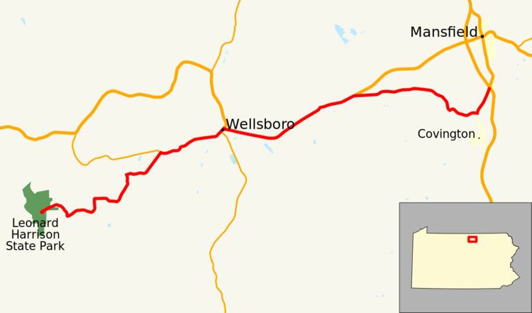
Pennsylvania Route 660 (designated by the Pennsylvania Department of Transportation as PA 660) is a 24.1-mile-long (38.8 km) state highway located in Tioga County in Pennsylvania. The western terminus is at the entrance of Leonard Harrison State Park in Shippen Township. The eastern terminus is at U.S. Route 15 and U.S. Route 15 Business in Richmond Township.
Contents
- Map of PA 660 Pennsylvania USA
- Leonard Harrison State Park to Wellsboro
- Charleston Township to Richmond Township
- Major intersections
- References
Map of PA-660, Pennsylvania, USA
Leonard Harrison State Park to Wellsboro
Route 660 begins at the entrance to Leonard Harrison State Park in Shippen Township. The route proceeds eastward out of the park into Shippen Township, reaching an intersection with State Route 3004 (Snyder Point Road), where the southeast-bound right-of-way is taken over for Route 660. Route 660 makes a short dip into the community of Kennedy, where it turns eastward at an intersection with Wilson Street. The highway makes a long eastward stretch through the rural areas of Tioga County, paralleling Route 3004 for a distance to the south. After the intersection with Martin Road, Route 660 turns northward, intersecting with Route 3004's other terminus, where it turns east along the right-of-way. A short distance later, Route 660 enters Thumptown, a local community in Delmar Township. There, the highway comes to an intersection with State Route 3006 (Stony Fork School Road) and State Route 3007 (West Branch Road). Route 660 turns to the northeast on the right-of-way once held by State Route 3007 and crosses through Delmar Township's rural surroundings before entering the community of Dexter, where Route 660 turns eastward at an intersection with State Route 3029 (Airport Road), which connects to Route 362 and Grand Canyon State Airport.
Meanwhile, Route 660 crosses through Dexter and continues in a general eastward manner until reaching Morral Road, where it proceeds northeastward once again. At this stretch, some residences appear along the side of the road and soon Route 660 intersects with the western terminus of Route 362, east of the Grand Canyon State Airport in Delmar Township. Like before, Route 660 turns along the right-of-way formerly used by Route 362, and begins crossing through a more developed portion of Delmar Township. Passing to the north of Tioga Country Club, Route 660 gains the moniker of Pinecreek Road before entering the borough of Wellsboro. In Wellsboro, Route 660 changes monikers to West Avenue, crossing through a dense portion of the center of the borough. After curving to the northeast once again at the intersection with Lincoln Street, the moniker changes to Main Street. After passing through more of the commercial district, Route 660 intersects with Route 287 (Central Avenue) in downtown Wellsboro. The two roads form a short concurrency before intersecting with U.S. Route 6 (East Avenue). At this intersection, Route 287 proceeds on a concurrency west with U.S. Route 6, while Route 660 proceeds east on its concurrency with U.S. Route 6. After the intersection, U.S. Route 6 and Route 660 head eastward through a more residential portion of Wellsboro. The two highways continue eastward as East Avenue, before proceeding to leave Wellsboro for Charleston Township.
Charleston Township to Richmond Township
After leaving Wellsboro for Charleston Township, the moniker switches to Grand Army of the Republic Highway, a name associated with U.S. Route 6 throughout the United States. The two roads almost immediately enters the hamlet of Pitts, which consists of a few residences and industries at the eastern edges of Wellsboro. U.S. Route 6 and Route 660 leave Pitts and bend to the northeast through Charleston Township, mainly rural for most of the trip. Both roads pass to the southeast of Dart Settlement and begin a parallel with an old alignment of U.S. Route 6 through Charleston Township. The old alignment merges in with the newer one at a bend in the highway, which turns eastward for a small strip before turning northeastward once again. At the intersection with Charleston Road in the community of Whitneyville, Route 660 turns eastward from U.S. Route 6 as North Elk Run Road. For a distance, Route 660 has a parallel with U.S. Route 6 through fields. Soon after, both roads cross into Richmond Township. The surroundings on Route 660 remain rural while the parallel begins to break at the intersection with Spencer Road, where the highway turns to the southeast. After the intersection with Mack Road, Route 660 enters some dense woods east of the community of Covington.
A short distance after leaving the woods, Route 660 enters Covington. In Covington, Route 660 intersects with the old alignment of U.S. Route 15 at North Williamson Road. PA 660 turns left onto the old US 15 alignment and passes through a mix of fields and residences as it reenters Richmond Township. This time, entering the community of Canoe Camp, the road crosses the former Erie Railroad Tioga Division right-of-way, and soon enters an interchange with U.S. Route 15 (Appalachian Throughway). This serves as the eastern terminus of Route 660, while the U.S. Route 15 Business continues northward into Mansfield.
Major intersections
The entire route is in Tioga County.