
Existed: by 1927 – present Length 58.27 km | Constructed 1928 | |
 | ||
Counties | ||
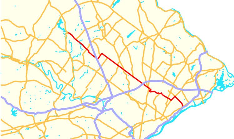
Pennsylvania Route 63 (PA 63) is a 37.4-mile-long (60.2 km) state highway located in the Philadelphia, Pennsylvania area. The western terminus of the route is at PA 29 in Green Lane, Montgomery County. The eastern terminus is at Interstate 95 (I-95) in Bensalem Township, Bucks County. The route heads through a mix of suburban and rural areas of northern Montgomery County as a two-lane road, passing through Harleysville, before coming to an interchange with I-476 (Pennsylvania Turnpike Northeast Extension) in Towamencin Township. From this point, PA 63 continues through predominantly suburban areas of eastern Montgomery County as a two- to four-lane road, passing through Lansdale, Maple Glen, Willow Grove, and Huntingdon Valley. Upon entering Northeast Philadelphia, the route follows Red Lion Road and U.S. Route 1 (US 1) before heading southeast on a freeway called Woodhaven Road to I-95.
Contents
- Map of PA 63 Pennsylvania USA
- Green Lane to Lansdale
- Lansdale to Willow Grove
- Willow Grove to Bensalem
- History
- PA 63 Alternate Truck
- Related routes
- References
Map of PA-63, Pennsylvania, USA
What would become PA 63 was originally designated as Legislative Route 198 in 1911, running from Green Lane to Northeast Philadelphia. When first designated, PA 63 ran from PA 29 in Green Lane to US 611 (now PA 611) in Willow Grove, following its current alignment. In 1928, it was extended east to PA 532 in Northeast Philadelphia, following Edge Hill Road, Terwood Road, and Welsh Road to Bethayres, where the route continued along Philmont Avenue to PA 532. By 1940, PA 63 was moved to its current alignment between Willow Grove and Bethayres and was realigned to follow Byberry Road to PA 532. The former alignment of PA 63 on Edge Hill Road and Terwood Road became PA 163, which was removed by 1950. In the 1950s, the Woodhaven Road freeway was planned to serve Northeast Philadelphia, connecting I-95 to PA 63 at Philmont Avenue, with a further extension to I-276 (Pennsylvania Turnpike) in Southampton once planned. The freeway was completed to Evans Street just west of US 1 in the 1960s and PA 63 was extended along Byberry Road and Woodhaven Road to end at I-95. In the 1980s, PA 63 was rerouted to use Red Lion Road and US 1 to reach Woodhaven Road. Plans to extend Woodhaven Road through the rest of Northeast Philadelphia remain, but have been on hold due to community opposition and financial constraints.
Green Lane to Lansdale
PA 63 begins at a "T" intersection with PA 29 in the borough of Green Lane in Montgomery County. From this intersection, the route heads southeast as two-lane undivided Main Street, passing by several homes. After crossing Upper Ridge Road, the road crosses into Marlborough Township and becomes Sumneytown Pike. PA 63 continues through rural areas with some development, passing through the community of Sumneytown. Upon crossing Unami Creek, the route enters Upper Salford Township and heads into forested areas, where PA 63 meets the southern terminus of PA 563 (Ridge Road). Following that intersection, the road passes through a mix of farmland, woodland, and residential developments. The route crosses over the East Branch of Perkiomen Creek before crossing into Lower Salford Township. At this point, PA 63 becomes Main Street and heads into the community of Harleysville, where it passes through suburban residential neighborhoods before heading into a commercial area, crossing PA 113 (Harleysville Pike).
In the area of this intersection, PA 63 is briefly a divided highway. After PA 113, the road passes through the center of Harleysville. The road turns south, becoming a three-lane road with a center left-turn lane before it heads to the southeast again as a two-lane road, continuing past a mix of farm fields and residential and commercial development. PA 63 bypasses the community of Mainland to the northeast with two westbound lanes and one eastbound lane before entering Towamencin Township near a crossing of Skippack Creek.
In Towamencin Township, PA 63 widens to four lanes and is called Sumneytown Pike again, passing woods and development before reaching an interchange with I-476 (Pennsylvania Turnpike Northeast Extension). Southeast of I-476, the route enters a commercial area, where the highway turns northeast onto Forty Foot Road, a five-lane road with a center left-turn lane. PA 63 passes through suburban areas, narrowing to three lanes before widening back to five lanes. Along this stretch, the route passes southeast of Christopher Dock Mennonite High School. A short distance later, PA 63 turns southeast onto Welsh Road and Forty Foot Road continues northeast toward Hatfield as PA 463. Along two-lane Welsh Road, PA 63 forms the border between Hatfield Township to the northeast and Towamencin Township to the southwest. The road heads through residential neighborhoods.
At the intersection with Squirrel Lane, PA 63 briefly forms the border between the borough of Lansdale to the northeast and Towamencin Township to the southwest before fully entering Lansdale and becoming Main Street. The road passes a mix of homes and businesses before coming to the northern terminus of PA 363 (Valley Forge Road). After the PA 363 intersection, the road runs through the downtown of Lansdale, where the route crosses SEPTA’s Lansdale/Doylestown Line near the Lansdale Transportation Center. The road leaves downtown and heads into areas of homes and businesses. At a crossing of Wissahickon Creek, PA 63 forms the border between Lansdale to the northeast and Upper Gwynedd Township to the southwest before running along the border of Montgomery Township and Upper Gwynedd Township after crossing North Wales Road.
Lansdale to Willow Grove
At North Wales Road, PA 63 again becomes Welsh Road and passes several businesses as a four-lane divided road. The route becomes a two-lane undivided road again as it passes between business parks to the northeast and farms and woods to the southwest ahead of an intersection with US 202 Bus. (Dekalb Pike). Upon intersecting US 202, PA 63 forms the border between Montgomery Township to the northeast and Lower Gwynedd Township to the southwest. The road passes through a mix of residential and commercial development, widening into a three-lane road with two westbound lanes and one eastbound lane. PA 63 becomes the border between Horsham Township and Lower Gwynedd Township and crosses PA 309 (Bethlehem Pike), with jughandles controlling the movements from PA 309 to PA 63.
The route narrows back to two lanes as it passes residential subdivisions, becoming the border between Horsham Township to the northeast and Upper Dublin Township to the southwest at the Tennis Avenue intersection. Upon reaching the community of Maple Glen, PA 63 passes businesses and crosses PA 152 (Limekiln Pike) and Norristown Road. Past Maple Glen, the road continues past more homes, along with a few farms.
Farther southeast, the route widens into a three-lane road with one eastbound lane and two westbound lanes as it passes near business parks. PA 63 soon widens to four lanes, with two lanes in each direction. The road becomes a five-lane road with a center left-turn lane as it comes to the Blair Mill Road intersection, at which point it forms the border between Upper Moreland Township to the northeast and Upper Dublin Township to the southwest.
The road becomes a four-lane divided highway that soon becomes undivided as it crosses over the Pennsylvania Turnpike (I-276) and Norfolk Southern’s Morrisville Line before heading into a mix of residential and commercial areas as a five-lane road again. Upon forming the border between Upper Moreland Township and Abington Township, PA 63 becomes Moreland Road, briefly becoming a divided highway. The route heads into the community of Willow Grove as a five-lane road. The road enters a business area, becoming a divided highway again as it passes to the northeast of the Willow Grove Park Mall. The road crosses Easton Road and becomes undivided as it crosses SEPTA’s Warminster Line. The route passes a mix of homes and businesses as it comes to an intersection with PA 611 (Old York Road).
Willow Grove to Bensalem
At this point, PA 63 heads into wooded residential areas as a two-lane road. At the intersection with Edge Hill Road, the route turns southwest onto that road and fully enters Abington Township, eventually turning southeast onto Old Welsh Road. The road curves to the east and crosses into Lower Moreland Township. The road becomes Welsh Road again and widens to four lanes as it enters a mix of residential and commercial establishments in the community of Huntingdon Valley, crossing the Pennypack Trail at the Terwood Road intersection and the Pennypack Creek. Upon crossing PA 232 (Huntingdon Pike), the route becomes Philmont Avenue and narrows back to two lanes. PA 63 turns south onto Red Lion Road and crosses SEPTA’s West Trenton Line as it continues through wooded residential subdivisions, making a turn to the southeast into Philadelphia.
PA 63 enters the Northeast Philadelphia section of the city a short distance past the Pine Road intersection. PA 63 widens into a four-lane divided highway and passes between the Island Green Country Club (site of the former Budd Company Red Lion plant) and residential and industrial developments to the south. The road continues through a mix of residential and commercial development as it crosses PA 532 (Bustleton Avenue). East of PA 532, the route passes over CSX’s Trenton Subdivision and comes to an intersection with US 1 (Roosevelt Boulevard).
PA 63 turns left and follows a concurrency with US 1, which at this point is a wide boulevard with local-express lanes. The road carries a 3-3-3-3 lane configuration as it heads northeast through areas of businesses and industrial parks. After intersecting Byberry Road, the concurrency with US 1 ends at a cloverleaf interchange, where PA 63 heads southeast onto the six-lane Woodhaven Road freeway, which is lined with frontage roads.
Woodhaven Road carries the route between an industrial park to the northeast and residential neighborhoods to the southwest as it comes to the Thornton Road interchange. Past here, the freeway passes residential areas on both sides and has interchanges with Academy Road and Knights Road. At this point, the surroundings along PA 63 become commercial as it comes to the Franklin Mills Boulevard/Millbrook Road interchange that provides access to the Philadelphia Mills shopping mall. Within the interchange, the road is temporarily four lanes wide. The frontage roads end past that interchange as Woodhaven Road turns south to cross Poquessing Creek and head into Bensalem Township in Bucks County. Upon entering Bucks County, PA 63 has an interchange with US 13. A short distance south of US 13, PA 63 ends at an interchange with I-95 at exit 35. This interchange also has access to the park and ride at the Cornwells Heights station on Amtrak’s Northeast Corridor and SEPTA’s Trenton Line.
Two portions of PA 63 are part of National Highway System: between I-476 and Sumneytown Pike in Towamencin Township and from Norristown Road in Maple Glen east to I-95 in Bensalem Township.
History
In 1911, what would become PA 63 was designated as Legislative Route 198 between Green Lane and Philadelphia. By 1927, PA 63 was designated to run from PA 29 in Green Lane to US 611 (now PA 611) in Willow Grove, following its current alignment. PA 63 was extended east to PA 532 in Philadelphia in 1928, following its current alignment between US 611 and Edge Hill Road in Willow Grove. From this intersection, the road followed Edge Hill Road and Terwood Road east before following Welsh Road to an intersection with PA 163/PA 232 in Bethayres and following Philmont Avenue between PA 163/PA 232 and PA 532.
By 1930, PA 63 had seven auxiliary routes: PA 163, PA 263, PA 363, PA 463, PA 563, PA 663, and PA 763. PA 63 was moved to its current alignment between Willow Grove and Bethayres by 1940, with the former alignment of the route between these two points becoming a rerouted PA 163. Also by this time, PA 63 was rerouted to follow Byberry Road between Philmont Avenue and PA 532. By 1950, the PA 163 designation was removed from Edge Hill Road and Terwood Road.
In 1954, the Philadelphia City Planning Commission planned a freeway named Woodhaven Road to run from I-95 in Bensalem Township northwest to Lower Moreland Township, passing through Northeast Philadelphia. Construction on Woodhaven Road began in 1962 with completion between I-95 and US 13 in 1963 and northwest past US 1 to Evans Street in 1966. Following the completion of the freeway, PA 63 was extended east onto it. By 1983, PA 63 was rerouted to use Red Lion Road and US 1 between Philmont Avenue and Woodhaven Road instead of Byberry Road.
The PA 63 freeway was at one time proposed to continue north from Northeast Philadelphia to the Pennsylvania Turnpike in Southampton. From here, the freeway would become known as the Cross County Expressway and serve the PA 611 corridor, utilizing the Doylestown Bypass as it continued north to the PA 33 freeway near Easton. The freeway south of the Pennsylvania Turnpike was planned to cost $68 million and be finished by 1975 while the part north of there was planned to be completed by 1985. However, this freeway was never built. Meanwhile, plans still existed to extend Woodhaven Road from Evans Street to the Montgomery County border at Philmont Avenue. This extension had been approved by the Federal Highway Administration in 1968 and PennDOT had torn down 28 homes in the Somerton neighborhood in order to build the road. The Woodhaven Road extension was cancelled in the late 1970s due to funding issues and opposition from Lower Moreland Township residents who did not want to see increased congestion from the extension.
In 1988, the Woodhaven Road extension resurfaced as a means to relieve traffic along Byberry Road. This proposed extension was to continue west only to PA 532 (Bustleton Avenue). However, Lower Moreland Township officials again voiced their opposition that the extension would increase traffic on area roads. In addition, residents in the Westwood development blocked the proposed road. PennDOT removed the Woodhaven Road extension from its long-range plans in 1996.
Despite this, plans for extending Woodhaven Road resurfaced in 2001 when local officials began discussing the extension with PennDOT. Various options for the extension were created, including extending the freeway as far as Philmont Avenue and possibly PA 232 (Huntingdon Pike) as well as widening and improving adjacent roads including PA 532 (Bustleton Avenue) and Byberry Road. In addition, the project also calls for replacing the weight-restricted Byberry Road bridge over a CSX rail line.
After putting the Woodhaven Road project on hold due to budget issues, PennDOT brought it back again as a parkway that is to continue west to PA 532, with an estimated cost of $30 million. Under this proposal, the railroad bridge is to be replaced, with Byberry Road terminating at cul-de-sacs on both sides. The current Woodhaven Road extension plan continues to face opposition from area residents who fear increased traffic.
In June 2011, the portion of PA 63 in Mainland between Freed Road and Old Forty Foot Road was shifted to a new alignment to the northeast, with the old alignment becoming Mainland Road.
PA 63 Alternate Truck
Pennsylvania Route 63 Alternate Truck is a truck route around a weight-restricted bridge over the Unami Creek in Marlborough Township, on which trucks over 30 tons and combination loads over 40 tons are prohibited. The route follows PA 29, Park Avenue, Schwenksville Road, and Old Skippack Road. It was signed in 2013.