
Existed: 1928 – present Length 55 km | Constructed 1928 | |
 | ||
Counties | ||
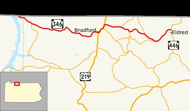
Pennsylvania Route 346 (PA 346) is a 34.177-mile (55.003 km) state highway located in Warren and McKean counties in Pennsylvania, United States The western terminus is at the New York state line in the Allegheny National Forest, where it becomes New York State Route 280 (NY 280). The eastern terminus is at an intersection with PA 446 in Eldred. The route is mostly a two-lane road that passes through rural areas in the northern part of McKean County. PA 346 passes through the city of Bradford, where it has a concurrency with the U.S. Route 219 (US 219) freeway.
Contents
Map of PA-346, Bradford, PA 16701, USA
PA 346 was designated in 1928 between Foster Brook and Eldred. The route was extended to PA 159 in Corydon in 1935 and south along the former PA 159 in 1946. PA 346 was rerouted to its current western terminus when the Allegheny Reservoir was created in the 1960s. The route was moved onto the US 219 freeway in Bradford in 1977.
Route description
PA 346 begins at the Pennsylvania–New York state line in the Allegheny National Forest as a continuation of NY 280. The route runs southeast through the forest along Willow Bay of the Allegheny Reservoir. Soon the route runs east from Warren County to McKean County. Leaving Willow Bay, PA 346 turns southeast again through the forest and runs into the intersection with the northern end of PA 321.
After bending eastward again, PA 346 wanders east through the forest for several miles through The Willows and the route bends northwest and soon to the southeast. After numerous changes in direction, PA 346 reaches Hazelton Mills and leaves the dense forest for a suburb of Bradford. In Hazelton Mills, the route turns northeast and enters the city of Bradford as West Washington Street. A two-lane city street, PA 346 runs east and turns south at an intersection with Mechanic Street. PA 346 runs south on Mechanic Street for three blocks, turning east onto Main Street.
Running east along Main Street, PA 346 reaches the intersection with Davis Street, where it turns north on Davis. Two blocks north, the route turns east again, this time on Forman Street. PA 346 reaches an interchange with US 219 and turns north to join the freeway. US 219 and PA 346 run northeast through Bradford, passing through the industrial sector of the city and an interchange with PA 46 (North Kendall Street). The freeway continues northeast through Bradford until PA 346 turns off at an interchange with Bolivar Drive.
PA 346 now runs east along Bolivar Drive through East Bradford as a two-lane city street. After crossing East Main Street, the route leaves the city of Bradford and changes names to Derrick Road as it enters Foster Township. PA 346 wanders east and southeast through Foster Township, the route reaches the village of Derrick City, where it intersects with PA 646 (Olean Road). PA 346 and PA 646 become concurrent and wander southeast through rural Foster Township.
At the junction with Old Plank Road, PA 646 turns for the south while PA 346 continues east and northeast into Otto Township. After a bend to the southeast, the route reaches the village of Duke Center, where it reaches the southern terminus of PA 546. Running southeast from PA 546, PA 346 starts paralleling PA 246 before the two roads intersect in Otto Township. After PA 246, the route turns northeast once again and crosses into the borough of Eldred. In Eldred, PA 346 intersects with PA 446 and terminates.
History
PA 346 was assigned in the original assignment of state highways in Pennsylvania in 1928. It originally began in Foster Brook, north of Bradford, and ended in Eldred. It was extended westward in 1935 to a new terminus at Corydon, where it ended at PA 159, a north–south route assigned in 1928 that began at PA 59 in Cornplanter and followed the Allegheny River north to the New York state line. This 10-mile (16 km) alignment of PA 159 remained in place until 1946, when all of PA 159 south of Corydon was replaced by an extended PA 346. The short segment of PA 159 between Corydon and the state line became unnumbered.
When the Allegheny Reservoir was completed in 1967, the portion of PA 346 near the Allegheny River was permanently inundated. As a result, PA 346 was rerouted slightly on its existing western end to head northwest to the state line, where it connected to the rebuilt NY 280. Originally, PA 346 followed East Main Street in Bradford and Foster Brook. When the Bradford Bypass (US 219) was finished in 1977, the Pennsylvania Department of Transportation realigned PA 346 onto the bypass as well.