
Length 18.55 km | ||
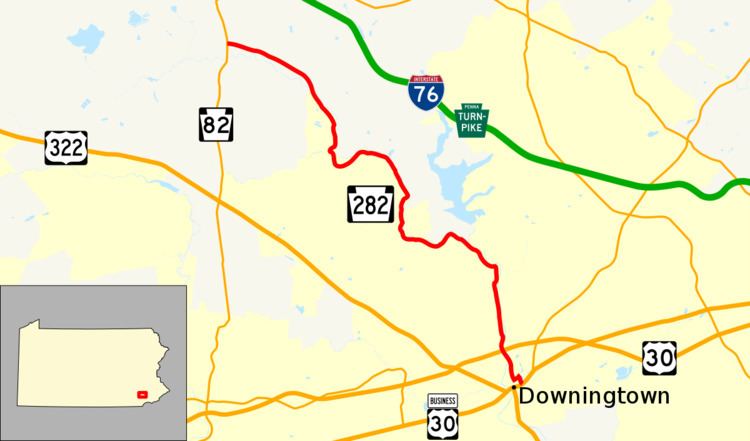 | ||
West end: PA 82 in West Nantmeal Township East end: US 30 Bus. in Downingtown | ||
Pennsylvania Route 282 (PA 282) is an 11.9-mile-long (19.2 km) state highway in Chester County, Pennsylvania. The route runs from PA 82 in West Nantmeal Township southeast to U.S. Route 30 Business (US 30 Bus.) in Downingtown. PA 282 follows Creek Road, a two-lane undivided road that winds along the East Branch Brandywine Creek through rural areas. The route passes through the communities of Glenmoore and Lyndell along the way. PA 282 was designated onto its current alignment in 1928.
Contents
Map of PA-282, Pennsylvania, USA
Route description
PA 282 begins at an intersection with PA 82 in West Nantmeal Township, Chester County, heading east on two-lane undivided Creek Road. The road passes through wooded areas with some fields, entering Wallace Township. Here, the route heads to the southeast and crosses the East Branch Brandywine Creek before it reaches the residential community of Glenmoore. Past here, PA 282 continues south through forested areas along the west bank of the East Branch Brandywine Creek. Near Springton Manor Farm, the road winds south before it makes a sharp turn to the northeast. The route curves to the southeast and passes to the west of Marsh Creek State Park as it enters East Brandywine Township. Here, PA 282 passes through the community of Lyndell and continues through rural areas alongside the creek, turning to the east. The road curves northeast and then southeast as it comes to the community of Dorlan. At this point, the route curves south and continues along the west bank of the East Branch Brandywine Creek while the Struble Trail runs along the east bank. PA 282 continues south through wooded areas and crosses into Caln Township, where it passes under the US 30 freeway. The route crosses the East Branch Brandywine Creek into East Caln Township and becomes Wallace Avenue. Here, PA 282 intersects Norwood Road, which heads north to an partial interchange providing access to eastbound US 30 and from westbound US 30. The road heads into commercial areas and enters the borough of Downingtown. Here, the route turns northeast onto Pennsylvania Avenue before a turn to the southeast onto four-lane Green Street. PA 282 reaches its eastern terminus at an intersection with US 30 Bus.
History
When Pennsylvania first legislated routes in 1911, present-day PA 282 was not given a route number. In 1928, PA 282 was designated onto its current alignment between PA 82 northwest of Glenmoore and US 30/PA 1 (now US 30 Bus.) in Downingtown. Upon designation, the entire length of the route was paved. The route has remained on the same alignment since it was first designated.
Major intersections
The entire route is in Chester County.
Downingtown
Pennsylvania Route 282 Alternate Truck is a route that goes through Downingtown bypassing a weight-restricted bridge over East Branch Brandywine Creek in which trucks over 30 tons and combination loads over 40 tons are prohibited. It follows PA 113, US 30, and Norwood Road. The route runs 4 miles in length and was signed in 2013.
Eagle
Pennsylvania Route 282 Alternate Truck is a truck route around a weight-restricted bridge over the East Branch Brandywine Creek in Eagle, Pennsylvania. It follows Moore Road, PA 100 and PA 113. Along PA 100, it runs concurrent with PA 401 Alternate Truck. The route is 7 miles in length and was signed in 2013.