
Constructed 1928 | Length 51.8 km | |
 | ||
Counties | ||
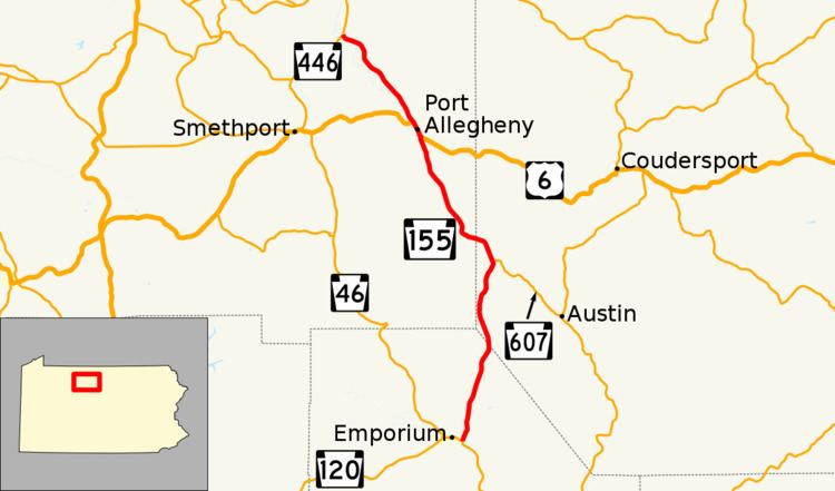
Pennsylvania Route 155 (PA 155) is a 32.2-mile-long (51.8 km) state highway located in Cameron, Potter and McKean Counties in Pennsylvania. The southern terminus is at PA 120 in Emporium. The northern terminus is at PA 446 in Eldred Township.
Contents
Map of PA-155, Pennsylvania, USA
Route description
PA 155 begins at an intersection with PA 120 in the community of Emporium Junction in Shippen Township, Cameron County, heading north on two-lane undivided Sizerville Road. The road passes businesses and homes, passing through Prospect Park. The route heads through forested areas with some fields and residences, running to the east of the Sinnemahoning Portage Creek and a Western New York and Pennsylvania Railroad line. Farther north, PA 155 crosses the creek and heads to the north-northeast, continuing into Portage Township. Here, the route runs through small areas of agriculture before heading away from the creek and the railroad line and continuing into forests and passing to the west of Sizerville State Park.
PA 155 enters Portage Township in Potter County and becomes an unnamed road, passing more of the state park before continuing north through the Elk State Forest. The road heads into Keating Township and heads north-northeast, running to the east of the Western New York and Pennsylvania Railroad line. In the community of Keating Summit, the route intersects the western terminus of PA 607 and heads north-northwest through more forests with some fields, turning to the northwest.
PA 155 heads into Liberty Township in McKean County and becomes Port-Emporium Road, heading through more forested areas with some fields and residences, passing through Liberty. The route turns to the northwest and heads into more agricultural areas with some homes, with the Portage Creek and the railroad line a short distance to the west of the road. The road heads through Wrights and continues through more rural areas. Farther north, PA 155 crosses the Allegheny River into Port Allegany and comes to an intersection with US 6, turning northwest to form a concurrency with that route on South Main Street. The road passes homes, heading into the commercial downtown and becoming North Main Street. The two routes pass through more residential areas before US 6 splits from PA 155 by heading west on Grand Army of the Republic Highway. PA 155 heads back into Liberty Township and becomes Port-Turtlepoint Road, passing through a mix of farmland and woodland containing some homes, with the Allegheny River and the Western New York and Pennsylvania Railroad line located to the west of the road. The route heads into Annin Township and continues through more rural areas, passing through Turtlepoint, where it becomes Turtle Point-Larabee Road. The road runs through Sartwell and enters Eldred Township, continuing northwest through wooded areas with some fields and homes, ending at PA 446.