
Elevation 2,506 m Easiest route Climbing | Prominence 661 m Parent range Pyrenees | |
 | ||
Isolation 5.2 kilometres (3.2 mi) Translation Stone Pitchfork (Catalan) Similar Puigmal, Cap de la Gallina Pelada, Montserrat, Pica d'Estats, Comabona | ||
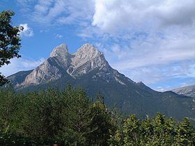
Pedraforca is a mountain in the Pre-Pyrenees, located in the comarca of Berguedà. The mountain's unique form, along with the fact that it is not visibly connected to any other adjacent mountains or ridges, has made it one of the most famous and emblematic mountains in the autonomous community of Catalonia, Spain.
Contents
Map of Pedraforca, 08697, Barcelona, Spain
DescriptionEdit
The mountain has a very peculiar shape, composed of two parallel ridges (the pollegons) joined by a neck (the Enforcadura). The upper ridge, named Pollegó Superior, has an elevation of 2,506.4 m while the secondary peak, el Calderer is 2,496.4 m high. The ridge below, Pollegó Inferior is 2,444.8 m tall, while Enforcadura's highest point lies at 2,356.2 m.
LocationEdit
Located within the Cadí-Moixeró Natural Park, Pedraforca has been declared a Natural Site of National Interest by the Generalitat de Catalunya.
The closest villages to Pedraforca are Gósol to the west and Saldes to the east. Pedraforca marks the boundary between the two municipalities, as well as between the provinces of Barcelona and Lleida.
SignificanceEdit
Pedraforca is, along with the mountains of Montserrat and Canigó, one of the emblematic mountains of Catalonia. This fame has made Pedraforca a popular destination for hikers and rock climbers, as well as being used by the comarca of Bergudà in its coat of arms.