
Country United States Time zone Eastern (EST) (UTC-5) Elevation 141 m Zip code 12564 Local time Saturday 1:06 AM | FIPS code 36-56814 Area 5.2 km² Population 2,347 (2013) Area code 845 | |
 | ||
Weather 5°C, Wind W at 5 km/h, 68% Humidity | ||
Pawling is a village in Dutchess County, New York, United States. The population was 2,347 at the 2010 census. It is part of the Poughkeepsie–Newburgh–Middletown, NY Metropolitan Statistical Area as well as the larger New York–Newark–Bridgeport, NY-NJ-CT-PA Combined Statistical Area. The John Kane House, a registered historic place, is situated in the village. The village was portrayed as the fictional town of Denning, New York, in the TV series Elementary.
Contents
- Map of Pawling NY 12564 USA
- History
- Geography
- Government
- Fire
- Police
- Medical
- Demographics
- Transportation
- References
Map of Pawling, NY 12564, USA
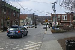
The village of Pawling is centrally located in the town of Pawling by the junction of Routes 22 and 55.
History
The village was incorporated in 1893.
Geography
Pawling is located in southeastern Dutchess County at 41°33′43″N 73°35′54″W (41.562053, -73.598503).
According to the United States Census Bureau, the village has a total area of 2.0 square miles (5.2 km2), all of it land.
Government
Since 1893 Pawling has operated under a Mayor and Village Board of Trustees government. The mayor is the chief administrative officer of the village, selected to carry out the directives of the Council. The Deputy mayor monitors the Village's fiscal condition and enforces its local ordinances and laws. The mayor is also involved in the discussion of all matters coming before Council and votes on resolutions. The Village Board of Trustees is the legislative body consisting of the mayor and four trustees. The Mayor serves as the presiding officer of the Council. The Council functions to set policy, approve the annual budget, and enact local laws, resolutions & ordinances.
Fire
The Pawling Fire District is the fire department that covers the Town Of Pawling. By keeping buildings up to code, controlling illegal occupancies, monitoring the safety of living-areas and issuing licenses and permits, the department works to control the potential for dangerous situations. The fire district operates three fire stations spread out all over the town, as their district covers a large area. The department is capable of handling fires, rescues, extrications and natural disasters. The PFD operates a varied fire apparatus fleet, however does not provide Emergency Medical Services. Both BLS and ALS EMS calls are handled by TransCare who are contracted to provide the town one ambulance to provide 24/7 ambulance service. In the event of numerous calls within a short amount of time, TransCare ambulances are pulled from neighboring town Beekman, or if a backfil unit is available, it will respond from Wappingers Falls.
Police
Police protection to the Town of Pawling is provided by the Dutchess County Sheriff's Office and New York State Police. The DCSO have a substation located in the middle of town, near the train station. When someone calls 911, the call is routed to the Dutchess 911 center in Poughkeepsie, New York and then police are polled for, and the closest unit responds. The MTA Police also cover the center of town as the Metro-North Railroad Harlem Line passes through town and with a train station.
Medical
Pawling has no medical facilities, but within a short distance are four medical centers. Saint Francis Hospital SFH and Vassar Brothers Medical Center VBH are located in nearby Poughkeepsie, New York. Putnam Hospital Center PHC is located in Carmel, New York in Putnam County. New Milford Hospital, is located in New Milford, CT.
Demographics
As of the census of 2000, there were 2,233 people, 919 households, and 533 families residing in the village. The population density was 1,096.4 people per square mile (422.6/km²). There were 945 housing units at an average density of 464.0 per square mile (178.9/km²). The racial makeup of the village was 90.77% White, 2.24% Black or African American, 0.36% Native American, 1.70% Asian, 0.13% Pacific Islander, 2.87% from other races, and 1.93% from two or more races. Hispanic or Latino of any race were 6.94% of the population.
There were 919 households out of which 27.2% had children under the age of 18 living with them, 45.3% were married couples living together, 8.7% had a female householder with no husband present, and 42.0% were non-families. 37.2% of all households were made up of individuals and 17.5% had someone living alone who was 65 years of age or older. The average household size was 2.31 and the average family size was 3.07.
In the village, the population was spread out with 21.6% under the age of 18, 5.6% from 18 to 24, 28.3% from 25 to 44, 22.3% from 45 to 64, and 22.2% who were 65 years of age or older. The median age was 41 years. For every 100 females there were 89.6 males. For every 100 females age 18 and over, there were 84.9 males.
The median income for a household in the village was $46,484, and the median income for a family was $59,896. Males had a median income of $43,266 versus $31,466 for females. The per capita income for the village was $23,512. About 5.2% of families and 7.3% of the population were below the poverty line, including 3.5% of those under age 18 and 9.6% of those age 65 or over.
Transportation
Two main thoroughfares run through Pawling, State Route 22 & State Route 55. State Route 22 runs through every town on the East side of Dutchess County, and runs parallel the Business District of Pawling. Metro-North Railroad has two rail commuter rail stations in Pawling, with service to New York City via the Harlem Line, with the Pawling in the town center, and the Appalachian Trail 2 miles north of the village of Pawling.
Local transit service is available on Dutchess LOOP's route E to Poughkeepsie.