
Area 2,097 km² Region Ayacucho Region | UBIGEO 0508 | |
 | ||
Paucar del Sara Sara Province is a province located in the south-eastern corner of the Ayacucho Region of Peru. It is one of eleven provinces that make up the region. The province has a population of 10,610 inhabitants 2005 census. It is bounded to the north and west by the Parinacochas Province and to the south and east by the Arequipa Region. The capital of this province is the city of Pausa.
Contents
Map of Paucar del Sara Sara Province, Peru
Geography
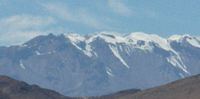
The highest mountain in the province is Sara Sara at 5,505 m (18,061 ft) on the border to the Parinacochas Province. Other mountains are listed below:
Political division
The province extends over an area of 2,096.92 square kilometres (809.63 sq mi) and is divided into ten districts. The districts, with their capitals in parenthesis, are:
Ethnic groups
The people in the province are mainly indigenous citizens of Quechua descent. Quechua is the language which the majority of the population (50.15%) learnt to speak in childhood, 49.36 % of the residents started speaking using the Spanish language (2007 Peru Census).