
Traversed by D17/D680 Elevation 1,589 m | ||
 | ||
Similar | ||
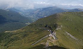
V lo en auvergne monts du cantal pierrefort col du pas de peyrol
Pas de Peyrol (el. 1,589 m) is a mountain pass located in Auvergne, France, and is the highest road pass in the Massif Central. The pass is on the slopes of Puy Mary (1,787 m) and is situated at the junction of three roads:
Contents
- V lo en auvergne monts du cantal pierrefort col du pas de peyrol
- Map of Pas de Peyrol 15380 Le Claux France
- Descent of the pas de peyrol
- Tour de FranceEdit
- Appearances in the Tour de FranceEdit
- References
Map of Pas de Peyrol, 15380 Le Claux, France
Descent of the pas de peyrol
Tour de FranceEdit
The pass is regularly used on the Tour de France, most recently on stage 5 of the 2016 tour. The pass was first used in the 1959 Tour de France, on the 231 km stage 14 from Aurillac to Clermont Ferrand, with Louis Bergaud first across the summit. In the 2004 tour, the pass was used on stage 10 from Limoges to Saint-Flour, approaching from the Salers direction which includes a final three kilometres at an average of 12% and a maximum gradient of 15%, with Richard Virenque first over the summit.
Appearances in the Tour de FranceEdit
The Tour de France has crossed the summit 10 times since 1947, including stage 5 of the 2016 tour on July 6th, 2016. The 10th stage was selected for the 2004 L'Étape du Tour, in which amateur and club riders ride over a full stage of the tour.