
Reference no. DE: 1642 Length 16,500 m | ||
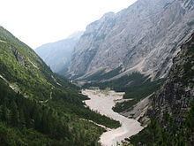 | ||
Main source on the Zugspitze Massifca. 1,440 m River mouth in Garmisch-Partenkirchen into the Loisachca. 690 m Similar Partnach Gorge, Alps, Reintalanger Hut, Knorr Hut, Höllental | ||
Gorge partnach gorge partnachklamm garmisch partenkirchen bayern german
The Partnach is a 16.5 km long Bavarian mountain river. It rises at a height of 1,440 m on the Zugspitze Massif. The Partnach is fed by meltwaters from the Schneeferner glacier some 1100 m higher up. The glacier’s meltwaters seep into the karsty bedrock and reach the surface again near the source of the Partnach.
Contents
- Gorge partnach gorge partnachklamm garmisch partenkirchen bayern german
- Map of Partnach Garmisch Partenkirchen Germany
- TributariesEdit
- References
Map of Partnach, Garmisch-Partenkirchen, Germany
The Partnach then flows down the Reintal valley. Until 2005 there were two mountain lakes here – the Vordere and Hintere Blaue Gumpe. At the first lake the water of the Partnach was impounded by scree from rock slides. As a result of heavy rain the natural dam, caused by rockfalls, was partially carried away and the lake was completed filled with sediment. As a result the Blaue Gumpe does not exist any longer today.
TributariesEdit
The Partnach has the following tributaries which join it at or near the river kilometre shown in brackets: