
Population 12,199 (2011.Ward) Local time Thursday 6:03 PM Dialling code 01744 | OS grid reference SJ525951 Sovereign state United Kingdom | |
 | ||
Weather 10°C, Wind E at 26 km/h, 57% Humidity | ||
Parr is a large township, now situated within St. Helens, England and is located towards the eastern side of the town. The population of the ward at the 2011 census was 12,199. However the area dates back to the West Derby hundred district from the 12th century. The area forms part of St Helens town centre.
Contents
Map of Parr, Saint Helens, UK
History
In the mid 14th century, the manor of Parr was held by William Dacre, 2nd Baron Dacre.
Parr was one of four townships that joined together, for administrative purposes, to become St. Helens, the others being Sutton, Eccleston and Windle.
The Sankey Canal, also known as the Sankey Brook Navigation and St Helens Canal, flows through Parr. When opened in 1757, it ran from close to the mouth of Sankey Brook at the River Mersey along the valley of the Sankey Brook, ending north east of St Helens. Later extensions were made at the Mersey end, firstly to Fiddlers Ferry, then to Widnes, and at the northern end, where it was extended into what became the centre of St Helens.
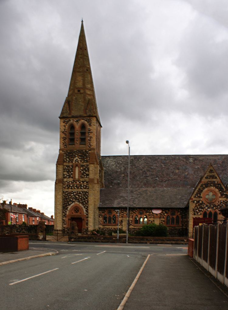
St Peter's Church was built in 1864-65 to the designs of J. Medland Taylor: the stonework is in three different colours and there is a broach spire.
The area was overlooked by Bold Power Station across "The Moss" until the decommissioned station was demolished in the late 90s.
Parr has a historical link to the Parr family, most famously represented by Henry VIII's final wife Catherine Parr. Her Father Sir Thomas Parr is known to have owned or rented lands in the area. The family seat was Parr Hall, sited in the Redgate area close to where Frodsham Drive is today.
Housing
The area of Parr is predominately Council Housing, represented by three main stages of developments. Waring Avenue Estate (developed 1950s / 60s), Concourse Way (colloquially referred to as Cement City in reference to its Pebble Dash rendering) developed in the 1960s, The Pennine Drive Estate developed in the 1950s. Amidst these estates remain the more traditional buildings dating to the 1930s, along with Terrace Housing (1890s onwards) and private developments.
The area succumbed to social problems linked to poverty and an aging population during the 1980s with the collapse of several significant employers in St. Helens. Its housing remains markedly cheaper than other areas of St. Helens due to a commonly perceived stigma of high crime and low education standards.
Since 2006 the area, as well as other areas of St. Helens in coordination with Re:new Neighbourhood Management Project, has been targeted for regeneration. Parr was selected for the Pilot scheme and has seen increased funding to local parks and green spaces (The Duckeries for instance, formerly a slag heap, is now in the process of returning the land to its marshy origins, whilst new multi-sporting facilities and park equipment have been added to Gaskell Park and others).
In coordination with Helena Housing many council and private properties have been refurbished with new exterior walls, adding a new roof to each property, UPVC doors and double glazing. Other projects have included a government incentive schemes for loft insulation, cavity insulation and secure gated schemes for alley access.
Recently a new private housing development of detached houses, terraced homes, and flats was completed along Newton Road and adjacent to the Derbyshire Hill area, with more new-builds developed on Ashtons Green Drive, and Fleet Lane.
Transport
Parr has three main access routes. The A572 (Newton Road) linking to Newton-Le-Willows, the A572 (Parr Stocks Road), a direct route into St. Helens town centre and the B5204 towards Burtonwood, Warrington.
Education
There are currently no non-denominational high schools located in Parr, since the closure of Parr High School. St. Cuthbert's is the only secondary establishment, resting on the junction of Watery Lane and Berry's Lane and the boundary of Sutton (their official address is in fact "Sutton"). St. Augustine's is located in nearby Blackbrook.
After Parr High School closed, many students attend Haydock High School.
Sport
There are no professional sporting clubs or organisations in Parr. The area boasts a series of playing fields where the local combination football league and rugby fixtures are played as well. One of St. Helens' swimming baths is also located in the area.
Blackbrook ARLFC is situated in the Blackbrook area of Parr.
Notable People
The wealthy entrepreneur John Rylands was born in Parr in 1801. Martin Murray also grew up in the area.