
Elevation c. 360 m (c. 1,180 ft) Topo map OS Landranger 119 | Prominence c. 35 m OS grid SK079669 | |
 | ||
Similar Chrome Hill, Peak District, High Wheeldon, Axe Edge Moor, Shutlingsloe | ||
Peak district walk chrome parkhouse hill
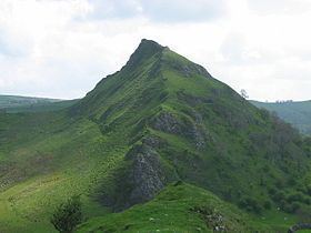
Parkhouse Hill is a small but distinctive hill in the Peak District National Park in the English county of Derbyshire. It lies on the north side of the River Dove, close to the border with Staffordshire.
Contents
- Peak district walk chrome parkhouse hill
- Map of Parkhouse Hill Buxton UK
- Chrome and parkhouse hills from longnor
- References
Map of Parkhouse Hill, Buxton, UK
Geologically, the hill is the remains of an atoll (a 'reef knoll') which is believed to have existed during the Carboniferous period when what is now the Peak District was covered by a tropical sea. Together with its higher but less distinctive neighbour, Chrome Hill, it forms the Chrome and Parkhouse Hills SSSI, cited for their geology and limestone flora.
For many years access to Parkhouse Hill was difficult, as there was no right of way to the summit. Access is now possible under the Countryside and Rights of Way Act 2000, as the hill is a designated access area.
In 1997, the writer Jeff Kent discovered that a double sunset could be seen against Parkhouse Hill from nearby Glutton Grange and, two years later, the phenomenon was first captured on film by the photographer Chris Doherty. The occurrence is visible in good weather in late March, early April and September, when the sun sets just to the south of the summit of the hill, begins to re-emerge almost immediately afterwards from its steep northern slope before fully reappearing and later sets for a second and final time at the foot of the hill. The precise event and its location are described in Kent's book The Mysterious Double Sunset.