
Fare zone 3 2013 1.64 million Address London, United Kingdom Number of platforms 2 | 2012 1.58 million 2014 1.98 million | |
 | ||
Park Royal is a station on the Piccadilly line of the London Underground. It is between North Ealing and Alperton and is in Travelcard Zone 3. It is situated on the south side of the east-west Western Avenue (A40), surrounded by residential Ealing and industrial Park Royal. There is a pedestrian subway under the A40 road near the station.
Contents
The station's platforms have a continuous significant gradient (sloping up from south to north).
History
The District Railway (DR, now the District line) opened the line through Park Royal on its new extension to South Harrow on 23 June 1903. A station, Park Royal & Twyford Abbey, was opened at that time a short distance to the north of the current station to serve the Royal Agricultural Society's recently opened Park Royal show grounds.
The current station was built for the extension of Piccadilly line services over the District line tracks to South Harrow. It opened on 6 July 1931 and replaced the earlier station which closed on the previous day.
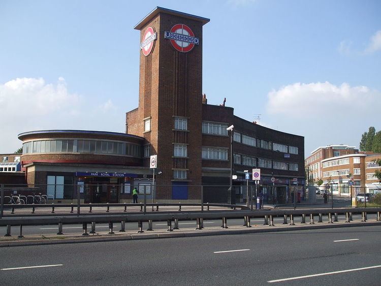
First opened as a temporary timber structure, the current station building was designed by Welch & Lander in an Art Deco/Streamline Moderne style influenced by the Underground's principal architect Charles Holden. The station buildings are formed from a series of simple interconnecting geometric shapes. Plain red brick masses are accented with strong horizontal and vertical glazed elements. A large circular ticket hall with high level windows gives access to the platform stairs. The enclosures for these form cascades of glazed steps down to the platforms. The most prominent feature of the station building is the tall square tower adjacent to the ticket hall. This is adorned with the Underground roundel; and represents a visible locator for the station from some distance. The permanent structure was opened in 1936. Attached to the station building and across the small open space of Hanger Green are two curved three-storey retail and office buildings built in the same style as the station.
On 4 July 1932, the Piccadilly line was extended to run west of its original terminus at Hammersmith sharing the route with the District line to Ealing Common. From Ealing Common to South Harrow, the District line was replaced by the Piccadilly line.
From 1 March 1936 until 1947 the station name was modified to Park Royal (Hanger Hill). The suffix was then dropped and the station returned to the unmodified version. Hanger Hill referred to a residential estate adjacent to the station.
Possible development
The Mayor's plans for the area include improvements to the station access.
The developers of the First Central business park at Park Royal were planning a new station between North Acton and Hanger Lane on the Central line. This would have served the business park and provide a walking distance interchange with Park Royal station. This is not being actively pursued. London Underground has said that the transport benefits of a Park Royal station on the Central line are not sufficiently high to justify the costs of construction.
Services
The off-peak service in trains per hour (tph) is:
The peak time service in trains per hour (tph) is:
Connections
London Buses routes 95 and 487 serve the station.