
Postal code 75980-000 | Time zone BRT/BRST (UTC-3/-2) Area 3,781 km² | |
 | ||
Microregion Vale do Rio dos Bois Microregion | ||
Paraúna is a municipality in southwestern Goiás state, Brazil. It has strange rock formations and is a large producer of cotton and soybeans.
Contents
- Map of ParaC3BAna State of GoiC3A1s Brazil
- Location
- Climate
- Political and Demographic Information
- Economic information
- Education 2006
- Health 2007
- Tourism
- History
- References
Map of Para%C3%BAna - State of Goi%C3%A1s, Brazil
Location
Highway connections with Goiânia are made by BR-060 / Abadia de Goiás / Guapó / Indiara / GO-320 / Jandaia. See Sepin for all the distances.
Municipal boundaries:
Climate
The climate is tropical, typical of medium elevations, with the dry period of the year occurring between July and October and the wet period occurring between November and March. The average elevation is 800 meters above sea level.
Political and Demographic Information
Economic information
The economy is based on agriculture, cattle raising, services, public administration, and small transformation industries.
See Sepin
Agricultural data for 2006
Education (2006)
Health (2007)
Tourism
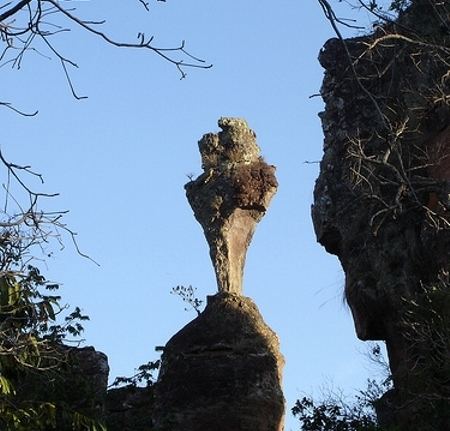
The municipality is one of the main tourist attractions in the state of Goiás. In the Serra do Caiapó immense stone walls extend for several kilometers. Inscriptions on the stone indicate to some the existence of a pre-Columbian civilization but to others the rocks are natural formations sculpted by the wind or the result of shaping caused by waves when this region was under the sea. Visitors describe a city of stone, with buildings, objects, and animals carved out by the forces of mother nature.
The Ecological Park of Paraúna is one of the most visited points of ecological tourism in the region. The park, which is being organized, has the mission of protecting the natural beauty of the region, such as the sandstone formations, caverns and a subterranean river.
History
The first name of the settlement, which appeared in the beginning of the nineteenth century, was Bota Fumaça (Fire Belcher) and then became São José do Turvo, due to the Turvo River. The present name, given in 1930, is of tupi-guarani origin. "Para" means river and "Una" means black. The town was elevated to the condition of municipality in 1934.
Ranking on the Municipal Human Development Index
Data are from 2000. For the complete list see Frigoletto.com