
Population 1,158 (2011 census) Postal code 3759 | Postcode(s) 3759 State electorate(s) EildonYan Yean Elevation 154 m | |
 | ||
Location 32 km (20 mi) from Melbourne4.2 km (3 mi) from Hurstbridge | ||
Panton Hill is a town in Victoria, Australia, 32 km north-east of Melbourne's Central Business District. Its local government area is the Shire of Nillumbik. At the 2011 Census, Panton Hill had a population of 1,158.
Contents
Map of Panton Hill VIC 3759, Australia
History
Originally called Kingstown, the area experienced population growth in the mid-1850s during the Victorian gold rush when prospectors mined the hills around the town known as the Caledonia Goldfields.
It was named after Joseph Anderson Panton, who was the magistrate at Heidelberg and spent much of his spare time mapping the Yarra Valley.
Panton Hill Post Office opened on 1 October 1875.
The Panton Hill Primary School, number 1134, was originally a two (2) room building with the Headmasters residence beside it.
Today
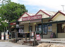
The town has a hotel. General Store/Post Office and a football team called the Panton Hill Redbacks, competing in the Northern Football League and a cricket club in the Diamond Valley Cricket Association, with 4 senior teams and 4 junior teams. It is also home to a small church, St. Matthews,() and several wineries including Panton Hill Winery.
Panton Hill Primary School has an enrolment of approximately 150. The nearest high schools are Diamond Valley Secondary College and Eltham College of Education. Panton Hill also has a volunteer Country Fire Brigade that services Panton Hill and the surrounding areas. A park in the centre of town has been dedicated to the memory of 5 of Panton Hill's firefighters who perished on Ash Wednesday. Panton Hill Primary School's houses are named after these firefighters.