
 | ||
Volcanic arc/belt Canadian Cascade ArcGaribaldi Volcanic Belt Similar Little Ring Mountain, Pyroclastic Peak, Middle Finger, Mount Frederick William, Mount Arthur | ||
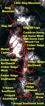
Pali Dome is a subglacial volcano in the Pacific Ranges of the Coast Mountains in southwestern British Columbia, Canada. It is part of the Mount Cayley volcanic field and its elevation is 2,250 m (7,380 ft). For the past 2 million years, the Mount Cayley volcanic field has had interactions between ice and lava which have created some unique landforms and an in-ice drainage system."Pali" comes from the Hawaiian word that means cliff or steep hill, while dome refers to the lava dome, which is when doughy lava flows from a volcanic vent which is usually rounded and flat on top.
Map of Pali Dome, Squamish-Lillooet D, BC, Canada
One of the last known eruptions of the Pali Dome was over 10,000 years ago.
References
Pali Dome Wikipedia(Text) CC BY-SA