
Location Pakxe 15/33 7,874 Elevation 107 m | Elevation AMSL 351 ft / 107 m 7,874 2,400 Code PKZ Operator Lao People's Armed Forces | |
 | ||
Airport type Military of Laos/Civil Aviation Authority | ||
Pakse International Airport (IATA: PKZ, ICAO: VLPS) is one of the few international airports in Laos. Pakse is the former southern capital city of the Champasak Kingdom.
Contents
Facilities
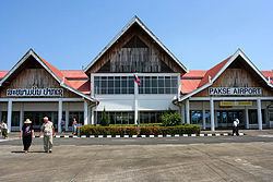
The airport has been in use since 1959. and re-opened after renovations in 2009. A new control tower next to the terminal replaced a short one to provide ATC at the airport. The terminal is designed to mimic the Lan Xang-style architecture used for Buddhist temples in Laos.
Though civilian, the airfield is also used by the military. Lao People's Army barracks and the headquarters of Military Region 4 are next to the airport. The airport is a military airfield for Lao People's Liberation Army Air Force aircraft as a detachment base.
Accidents and incidents
References
Pakse International Airport Wikipedia(Text) CC BY-SA