
Country United States FIPS code 48-54636 Elevation 497 m Zip code 76866 Local time Monday 2:34 PM | Time zone Central (CST) (UTC-6) GNIS feature ID 1364698 Area 4.3 km² Population 267 (2013) Area code 325 | |
 | ||
Weather 32°C, Wind S at 21 km/h, 29% Humidity | ||
Paint Rock is a town in and the county seat of Concho County, Texas, United States. The population was 273 at the 2010 census, down from 320 at the 2000 census.
Contents
Map of Paint Rock, TX 76866, USA
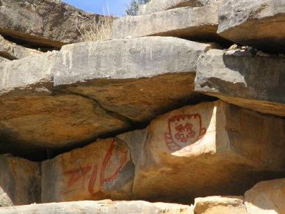
The town's name comes from Indian pictographs painted on cliffs overlooking the nearby Concho River. These pictographs cover nearly half a mile upstream from the town of Paint Rock. Some of the pictures painted on the rocks include animals, human figures, and handprints.
Geography
Paint Rock is located in northern Concho County at 31°30′28″N 99°55′24″W (31.507777, -99.923277), along U.S. Route 83. Eden is 20 miles (32 km) to the south and Ballinger is 16 miles (26 km) to the north via US 83, while San Angelo is 32 miles (51 km) to the west via secondary roads.
According to the United States Census Bureau, the town of Paint Rock has a total area of 1.64 square miles (4.26 km2), all of it land.
Demographics
As of the census of 2000, 320 people, 110 households, and 83 families resided in the town. The population density was 192.7 people per square mile (74.4/km2). The 126 housing units averaged 75.9 per square mile (29.3/km2). The racial makeup of the town was 77.19% White, 2.81% Native American, 19.69% from other races, and 0.31% from two or more races. Hispanics or Latinos were 28.44% of the population.
Of the 110 households, 41.8% had children under the age of 18 living with them, 64.5% were married couples living together, 9.1% had a female householder with no husband present, and 24.5% were not families. About 21.8% of all households were made up of individuals, and 9.1% had someone living alone who was 65 years of age or older. The average household size was 2.91 and the average family size was 3.45.
In the town, the population was distributed as 30.6% under the age of 18, 7.8% from 18 to 24, 26.6% from 25 to 44, 21.6% from 45 to 64, and 13.4% who were 65 years of age or older. The median age was 35 years. For every 100 females, there were 86.0 males. For every 100 females age 18 and over, there were 88.1 males.
The median income for a household in the town was $32,500, and for a family was $33,750. Males had a median income of $21,786 versus $21,250 for females. The per capita income for the town was $12,965. About 13.0% of families and 15.9% of the population were below the poverty line, including 24.7% of those under age 18 and 11.1% of those age 65 or over.
Education
The town is served by the Paint Rock Independent School District.
Climate
The climate in this area is characterized by hot, humid summers and generally mild to cool winters. According to the Köppen climate classification system, Paint Rock has a humid subtropical climate, Cfa on climate maps.