
Mountain type Stratovolcano Prominence 2,593 m | Elevation 2,744 m Last eruption 1903 | |
 | ||
Listing Country high pointUltra Location Ryanggang, North KoreaJilin, China Similar Jirisan, Hallasan, Seoraksan, Mount Kumgang, Deogyusan | ||
Paektu mountain
Mount Paektu or Mount Baekdu is an active volcano on the border between North Korea and China. At 2,744 m (9,003 ft), it is the highest mountain of the Changbai and Baekdudaegan ranges. North and South Koreans consider the volcano and its caldera lake to be their countries' spiritual home.
Contents
- Paektu mountain
- Map of Paektu Mountain
- Names
- Geography and geology
- Climate
- Eruptions
- Millennium eruption
- Tianwenfeng eruption
- Recent events
- Flora and fauna
- History
- China
- Korea
- Historical border disputes
- Recent border disputes
- Sightseeing
- References
Map of Paektu Mountain
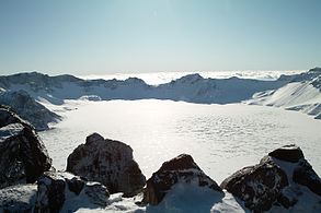
It is also the highest mountain on the Korean Peninsula and in Northeast China. A large crater lake, called Heaven Lake is in the caldera atop the mountain. The caldera was formed by the VEI 7 "Millennium" or "Tianchi" eruption of 946, which erupted about 100–120 km3 of tephra. This was one of the largest and most violent eruptions in the last 5000 years (alongside the Hatepe eruption of Lake Taupo at around 180 AD and the 1815 eruption of Tambora).
Names
The modern names of the mountain in Chinese and Korean come from the Sushen or Proto-Jurchen language of the Manchu peoples. Its modern Manchu name is Golmin Šanggiyan Alin or Long/Ever White Mountain. Similarly, its Mongolian name is Ondor Tsagaan Aula, the Lofty White Mountain.
In Chinese, the mountain itself is known as Chángbáishān ("Ever White Mountain") but the mountain and Heaven Lake taken together are known as Báitóushān ("Whitehead Mountain"). This later name, read in Korean and variously romanized, is the source of the North Korean name Paektu-san and South Korean Baekdu-san. In English, various authors have used non-standard transliterations.
Geography and geology
Mount Baekdu is a stratovolcano whose cone is truncated by a large caldera, about 5 km (3.1 mi) wide and 850 metres (2,790 ft) deep, partially filled by the waters of Heaven Lake. The caldera was created in or near 946 AD by the colossal (VEI=7) "Millennium" eruption. Volcanic ash from this eruption has been found as far away as the southern part of Hokkaidō, the northern island of Japan. The lake has a circumference of 12 to 14 kilometres (7.5 to 8.7 mi), with an average depth of 213 metres (699 ft) and maximum depth of 384 metres (1,260 ft). From mid-October to mid-June, the lake is typically covered with ice. In 2011, experts in North and South Korea met to discuss the potential for a significant eruption in the near future, as the volcano explodes to life every 100 years or so, the last time in 1903. Despite political tensions, Western scientists have also worked with North Korean scientists to study the volcano.
The geological forces forming Mount Paektu remain a mystery. Two leading theories are first a hot spot formation and second an uncharted portion of the Pacific Plate sinking beneath Mount Paektun.
The central section of the mountain rises about 3 mm per year due to rising levels of magma below the central part of the mountain. Sixteen peaks exceeding 2,500 m (8,200 ft) line the caldera rim surrounding Heaven Lake. The highest peak, called Janggun Peak, is covered in snow about eight months of the year. The slope is relatively gentle until about 1,800 m (5,910 ft).
Water flows north out of the lake, and near the outlet there is a 70 metres (230 ft) waterfall. The mountain is the source of the Songhua, Tumen and Yalu rivers. The Tumen and the Yalu form the northern border between North Korea and Russia and China.
Climate
The weather on the mountain can be very erratic, sometimes severe. The annual average temperature at the peak is −8.3 °C (17.1 °F). During summer, temperatures of about 18 °C (64 °F) or higher can be reached, and during winter temperatures can drop to −48 °C (−54 °F). Average temperature is about −24 °C (−11 °F) in January, and 10 °C (50 °F) in July, remaining below freezing for eight months of the year. Average wind speed is 42 kilometres (26.1 mi) per hour, peaking at 63 kilometres (39.1 mi) per hour. Relative humidity averages 74%.
Eruptions
Mount Baekdu has had at least two ignimbrite-forming eruptions in the past 5000 years. The tephra from the later eruption have been found in Greenland, which agree with the age of Mount Beakdu eruption. The 946 AD eruption has been dubbed the "Millennium eruption", while the earlier eruption is referred to as the "Tianwenfen eruption".
Millennium eruption
The Millennium eruption was one of the largest and most violent eruptions in the last 5000 years (alongside the Hatepe eruption of Lake Taupo at around 180 AD and the 1815 eruption of Tambora), with a Volcanic Explosivity Index rating of 7. The Millennium eruption has been recorded in the book of Koryo History.
In the year of A.D. 946, "thunders from the heaven drum" (likely the explosions from the Millennium eruption) were heard in the city of Kaesong, then the capital of ancient Korea about 450 km south of the Paektusan volcano, which terrified the emperor so much that the convicts were pardoned and set free. According to the book of Heungboksa Temple History, on November 3 of the same year in the city of Nara (Japan), about 1100 km southeast from the Paektusan volcano, an event of "white ash rain" was recorded. Three months later, on February 7 of A.D. 947, "drum thunders" were heard in the city of Kyoto (Japan), about 1000 km southeast of the Paektu Mountain volcano, based on the written documentation in the book of Japan history. The Tianwenfeng eruption also has been record in the Manchurian myths. Manchus described the Paektu Mountain as "Fire Dragon", "Fire Demon" or "Heavenly Fire".
Tianwenfeng eruption
The age of the Tianwenfeng eruption is not clear, but the carbonized wood in Heifengkou lag breccia has been date around 4105 ± 90 B.P. This eruption formed large areas covered in yellow pumice and ignimbrite. The eruption released about 23.14 megatons of SO2 into stratosphere. The bulk volume of the ejecta is at least 100 km³, making the Tianwenfeng eruption also of VEI 7.
Recent events
After these major eruptions, Paektu Mountain had at least 3 smaller eruptions, which occurred in 1668, 1702, and 1903, likely forming the Baguamiao ignimbrite, the Wuhaojie fine pumice and the Liuhaojie tuff ring.
In 2014, the Government of North Korea invited volcanologists James Hammond of Imperial College, London and Clive Oppenheimer of the University of Cambridge to study the mountain for recent volcanic activity. Their work is expected to last for "two or three years".
Flora and fauna
There are five known species of plants in the lake on the peak, and some 168 were counted along its shores. The forest on the Chinese side is ancient and almost unaltered by humans. Birch predominates near the tree line, and pine lower down, mixed with other species. In recent decades, significant climate warming has resulted in changes in the structure of the ancient forests on the upper slopes, with a change over from birch to more pine, and a thickening of the forest canopy. There has been extensive deforestation on the lower slopes on the North Korean side of the mountain.
The area is a known habitat for Siberian tigers, bears, Amur leopards, wolves, and wild boars. The Ussuri dholes may have been extirpated from the area. Deer in the mountain forests, which cover the mountain up to about 2000 metres, are of the Paekdusan roe deer kind. Many wild birds such as black grouse, owls, and woodpecker are known to inhabit the area. The mountain has been identified by BirdLife International as an Important Bird Area (IBA) because it supports a population of scaly-sided mergansers.
History
Mount Baekdu has been worshipped by the surrounding peoples throughout history. Both the Koreans and Manchus consider it the place of their ancestral origin.
China
Mount Baektu was first recorded in the Chinese Classic of Mountains and Seas under the name Buxian Shan (Chinese: 不咸山). It is also called Shanshan Daling (Chinese: 單單大嶺) in the Book of the Later Han. In the New Book of Tang, it was called Taibai Shan (Chinese: 太白山). The current Chinese name Changbai Shan was first used in the Liao dynasty (907–1125) of the Khitans and then the Jin dynasty (1115–1234) of the Jurchens. The Jin dynasty bestowed the title "the King Who Makes the Nation Prosperous and Answers with Miracles" (Chinese: 興國靈應王) on the sanshin in 1172 and it was promoted to "the Emperor Who Cleared the Sky with Tremendous Sagehood" (Chinese: 開天宏聖帝) in 1193.
The Manchu clan Aisin Gioro, which founded the Qing dynasty in China, claimed their progenitor Bukūri Yongšon was conceived near Paektu Mountain.
Korea
The mountain was considered sacred by Koreans throughout history. According to Korean mythology, it was the birthplace of Dangun, the founder of the first Korean kingdom, Gojoseon (2333 BC–108 BC), whose parents were said to be Hwanung, the Son of Heaven, and a bear who had been transformed into a woman. Many subsequent kingdoms of Korea, such as Buyeo, Goguryeo, Balhae, Goryeo and Joseon worshipped the mountain.
The Goryeo dynasty (935–1392) first called the mountain Baekdu, recording that the Jurchens across the Yalu River were made to live outside of Mount Paektu. The Joseon Dynasty (1392–1910) recorded volcanic eruptions in 1597, 1668, and 1702. The 15th century, King Sejong the Great strengthened the fortification along the Tumen and Yalu rivers, making the mountain a natural border with the northern peoples. Some Koreans claim that the entire region near Mount Paektu and the Tumen River belongs to Korea and part of it was illegally given away by Japanese colonialists to China through the Gando Convention.
Dense forest around the mountain provided bases for Korean armed resistance against the Japanese occupation, and later communist guerrillas during the Korean War. Kim Il-sung organized his resistance against the Japanese forces there, and North Korea claims that Kim Jong-il was born there, although records outside of North Korea suggest that he was actually born in the Soviet Union.
North Korea appropriates the mountain's mythology in its propaganda and uses it like a brand-name, for example with the Paektusan rocket and the Paektusan computer. The peak is featured on the Emblem of North Korea, defined in Article 169 of the Constitution, which describes Mt Paektu as "the sacred mountain of the revolution". The mountain is often referred to in slogans such as: "Let us accomplish the Korean revolution in the revolutionary spirit of Paektu, the spirit of the blizzards of Paektu!" North Korean media even celebrates portentous natural phenomenon witnessed at the mountain.
Historical border disputes
According to Annals of the Joseon Dynasty, the Yalu (鴨綠江) and Tumen Rivers (土門江/圖們江) were set as the borders in the era of the founder of Joseon Dynasty, Taejo of Joseon (1335–1408). Because of the continuous entry of Korean people into Gando, a region in Manchuria that lay north of the Tumen, Manchu and Korean officials surveyed the area and negotiated a border agreement in 1712. To mark the agreement, they built a monument describing the boundary at a watershed, near the south of the crater lake at the mountain peak. The interpretation of the inscription caused a territorial dispute from the late 19th century to the early 20th century, and is still disputed by academics today. The 1909 Gando Convention between China and Japan, when Korea was under Japanese rule, recognized the area north and east as Chinese territory. The border was further clarified in 1962, when China and North Korea negotiated a border treaty on the mountain border in response to minor disputes. The two countries agreed to share the mountain and the lake at the peak, with Korea controlling approximately 54.5% and gaining approximately 230 km2 in the treaty.
Recent border disputes
Some South Korean groups argue that recent activities conducted on the Chinese side of the border, such as economic development, cultural festivals, infrastructure development, promotion of the tourism industry, attempts at registration as a World Heritage Site, and bids for a Winter Olympic Games, are an attempt to claim the mountain as Chinese territory. These groups object to China's use of Mount Changbai, which has been used since Liao Dynasty and the earlier Jin dynasty. Some groups also regard the entire mountain as Korean territory that was given away by North Korea in the Korean War. Both European maps and Chinese maps dating before the annexation of Mount Paektu and Gando show these areas to be under Korean Joseon Dynasty control.
During the 2007 Asian Winter Games, which were held in Changchun, China, a group of South Korean athletes held up signs during the award ceremony which stated "Mount Baektu is our territory" (both North Korea and South Korea claim each other's countries territory as their own). Chinese sports officials delivered a letter of protest on the grounds that political activities violated the spirit of the Olympics and were banned in the charter of the International Olympic Committee and the Olympic Council of Asia. The head of the Korea Olympic Committee responded by stating that the incident was accidental and held no political meaning. South Korea has attempted to avoid having this issue become a source of friction between South Korea and China. However, the athletes' gesture did not become as big an issue as Liancourt Rocks dispute and the Sea of Japan naming dispute.
The 2007 official National Atlas of Korea shows the boundary as per the 1962 agreement, roughly splitting the mountain and the caldera lake. However, South Korea, which claims all of North Korea as its territory, claims the caldera lake and the inside part of the ridge enclosing as South Korean territory.
Sightseeing
Foreign visitors, mostly South Koreans, usually climb the mountain from the Chinese side, although Mount Paektu is a common tourist destination for foreign tourists in North Korea. The Chinese touristic site is classified as a AAAAA scenic area by the China National Tourism Administration.
There are a number of monuments on the North Korean side of the mountain. Baekdu Spa is a natural spring and is used for bottled water. Pegae Hill is a camp site of the Korean People's Revolutionary Army (Chosŏn'gŭl: 조선인민혁명군; Hancha: 朝鮮人民革命軍) allegedly led by Kim Il-sung during their struggle against Japanese colonial rule. There are also a number of secret camps which are now open to the public. There are several waterfalls, including the Hyongje Falls which splits into two separate falls about a third of the way from the top. In 1992, on the occasion of the 80th birthday of Kim Il-sung, a gigantic sign consisting of metal letters reading "Holy mountain of the revolution" was erected on the side of the mountain. North Koreans claim that steps that lead to the top of the mountain contain 216 steps — symbolizing Kim Jong-il's date of birth, 16 February — but in reality there are more steps.