
Demonym(s) Padalkar Elevation 56 m Population 3,550 (2011) | Named for Purandar Jadhav Time zone IST (UTC+5:30) Local time Monday 4:51 PM | |
 | ||
Weather 22°C, Wind S at 24 km/h, 42% Humidity | ||
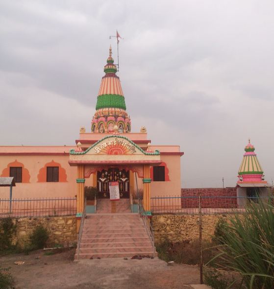
Padali ( पाडळी) is a census village in the Satara district, in the Indian state of Maharashtra. It is surrounded by a Big Mountain. There is a big temple of Heljaimata Madir at Village.It is a village surrounded by natural beauty with greenery of farms all around. Agriculture is the main land use in the village with more than 75% of the total area being used for agricultural activities.
Contents
- Map of Padali Maharashtra
- Demographics
- History
- Geography
- Occupation
- Notable People from Padali
- Nearby
- References
Map of Padali, Maharashtra
Padali is a large village located in Karad of Satara district, Maharashtra with total 350 families residing. As of 2011 India census, has population of 3560 of which 1689 are males while 1871 are females as per Population Census 2011.
In Padali village population of children with age 0-6 is 308 which makes up 10.75% of total population of village. Average Sex Ratio of Padali village is 1063 which is higher than Maharashtra state average of 929. Child Sex Ratio for the Padali as per census is 833, lower than Maharashtra average of 894.
Padali village has higher literacy rate compared to Maharashtra. In 2011, literacy rate of Padali village was 86.51% compared to 82.34% of Maharashtra. In Padali Male literacy stands at 92.14% while female literacy rate was 81.36%.
As per constitution of India and Panchyati Raaj Act, Padali village is administrated by Sarpanch (Head of Village) who is elected representative of village.
Schedule Caste (SC) constitutes 9.77% while Schedule Tribe (ST) were 0.77% of total population in Padali village.
Demographics
Marathi is the local language. The village normally shows unity as people from all castes Mainly Hindu Maratha and other which include Brahman, Lohar, Shimpi, Nhavi, Sonar, Parit, Mali, Chambar,Dhangar, Mang, Mahar, Boudhh etc.live in it. Two clans prominent in Padali are Jadhav and Shinde clans.Other surname clans also there like Chavan, Pawar, Kadam, Wagmode, etc.
History
As per constitution of India and Panchyati Raaj Act, Padali village is administrated by Sarpanch (Head of Village) who is elected representative of village.
List of Sarpanch
Geography
Padali is a village in Karad Taluka in Satara District of Maharashtra State, India. It belongs to Desh or Paschim Maharashtra region and to Pune Division. It is located 32 km towards South from district headquarters Satara, 28 km from Karad, 276 km from state capital Mumbai. Pin code is 415106 and post office is Padali (Satara). Gaikwadwadi(1.5 km), Gosavewadi(1.5 km), Banugadewadi(1.3 km), Wather( 5.3 km ), Sathewadi( 2.5 km ), are the nearby villages to Padali. Padali is surrounded by Karad Taluka towards North Kadegaon Taluka, Kadegaon Taluka towards South, Koregaon Taluka towards east, Patan Taluka towards west.
Satara, Wai, Mahabaleswar, Karad are the nearby cities.
Occupation
The Occupation of the village is mainly Agriculture and people used to do it. Some people are in the Politics,Army,Government administration, Education Field etc.But In this Village Most Young Generation Working In design Field. Like Piping, HVAC, Plumbing, Drainage, Electrical, Mechanical engineering field. there are around till year 2016. more than 200 Draughtsman in above mentioned field. mostly people working in Mumbai, Pune, & Arab states of the Persian Gulf.
Farmers are taking crops in their farm Season wise :-
Major crops (irrigated) are rice, Wheat, Gram, Sugarcane, Groundnut for 5 to 6 months (Except Sugar cane).
Major crops (non irrigated) are Sorghum Kharif and Rabi, Jawar, Groundnut for 3 to 4 months.
Major cash crops cultivated are Ginger (Ale) and Sugarcane (ऊस) for around 10 to 12 months.
Major plantations Fodder Development and Mixed planting goes through Every Year
Besides there is a wide cultivation of fruits like Mangoes and bananas. also cultivation of Flower like Gerbera, Dianthus caryophyllus, Chrysanthemum etc.
Notable People from Padali
Tanajirao Jadhav - Director, Sahyadri Shakari Sakhar Kharkhana, Yashwantnagar.
Shivajirao Uttamrao Jadhav - Vice -President,Karad North Nationalist Congress Party (NCP)
Nearby
Cities
Talukas
Airports
Tourist places
Forts
Districts
Railway station
Engineering Colleges Near Padali
Schools & Collages near Padali