
Capital Pachapaqui Time zone PET (UTC-5) Area 326.5 km² | Region Ancash Elevation 3,800 m (12,500 ft) UBIGEO 020504 | |
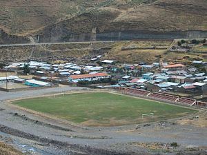 | ||
Pachapaqui is a village in the north of Aquia District in the Bolognesi Province of the Ancash Region, Peru. It has about a thousand inhabitants, mostly engaged in raising cattle and sheep, and small-scale agriculture.
Contents
Map of Pachapaqui, Peru
Location
It isocated at 3,800 m on a platform of uniform relief, on the western side of the Pativilca River. The distance to Lima is 350 km, to Huaraz in the Callejón de Huaylas 80 km and to Barranca 160 km.
Climate
Due to its altitude it is located in the Suni or Jalca region according to Javier Pulgar Vidal. The climate is mild and cold with annual temperature of 12 °C, dry during the months of May to October, precipitation from October to April. There may be some frost in June July and August. The rainy season is from December to March. It is characterized by heavy rainfall and occurrences of fog that can stay in the valleys all day long. There is frost in the months from July to September. The rest of the year is dry with mostly sunny days. However, in July and August there may be short rains and clouds.
Language
Fifty years ago, the main language was Quechua, different forms of Ancash Quechua. Now the dominant language is Castilian while Quechua is spoken almost entirely by the elderly due to the recent influx of new residents from the coast who speak only Spanish.
Tourism
Communication channels
Pachapaqui can be reached as follows: