
Gaelic name Pabaigh Area rank 136= Highest elevation 28 m Council area Highland | Norse name Papey OS grid reference NG674271 Area 122 ha Lieutenancy area Highland | |
 | ||
Island groups British Isles, Inner Hebrides | ||
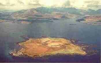
Pabay is a Scottish island just off the coast of the Skye.
Contents
Map of Pabay, United Kingdom
Geography
Pabay is an island in the Inner Sound of Skye, north of Broadford. It lies south of Longay and east of the larger Scalpay.
The island is formed of fossil-containing limestone, with some micaceous shale, named Pabba Shale. It forms a flat plateau with cliffs on the North and East shores. The surrounding low reefs encroach on its shores and double the area at low water.
History
Dean Monro in 1549 gave the following description:
At the shore of Skye foresaid, lies an isle called Pabay, near one mile in length, full of woods, good for fishing, and a main shelter for thieves and cut-throats, it pertains to Mackinnon.
Pabay was inhabited in the 19th century. The island has a single house and is only accessible by boat or helicopter.
It issues its own postage stamps.
Flora
Pabay's flora consists of heath, dry grassland, herb marsh, salt marsh, woodland remnants and 30.5 hectares (75 acres) of newly planted trees.
Art
"Cricket on Pabay" is a painting by Elizabeth Edenborough.