
Norse name Skalprøy OS grid reference NG605315 Area 24.83 km² | Meaning of name ship island Area rank 32 Council area Highland | |
 | ||
Gaelic name Sgalpaigh (an t-Sratha) Highest elevation Mullach na Càrn 396 m (1,299 ft) Island groups British Isles, Inner Hebrides | ||
Scalpay (Scottish Gaelic: Sgalpaigh) is an island in the Inner Hebrides of Scotland.
Contents
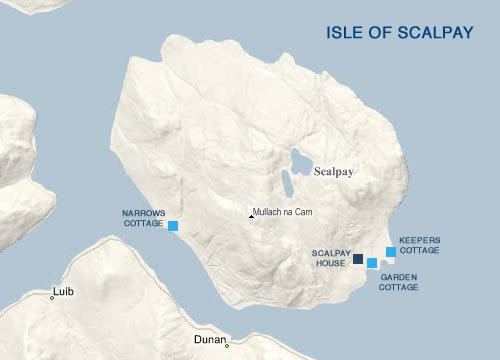
Map of Scalpay, Isle of Skye, UK
Geography
Separated from the east coast of Skye by Loch na Cairidh, Scalpay rises to 396 metres (1,299 ft) at Mullach na Càrn. It has an area of just under 25 square kilometres (9.7 sq mi). The island had a population of ten usual residents in 2001 and of four in 2011.
Scalpay is privately owned and operates a red deer farm, shooting estate and holiday cottages. Much of Scalpay is covered with heather, while other areas are conifer forestry plantations.
Etymology
Mac an Tàilleir (2003) suggests the name derives from "ship island" from the Norse. However, Haswell-Smith states that the Old Norse name was Skalprøy, meaning "scallop island".
History
Dean Monro gave the following description of Scalpay in 1549:
...a fair hunting forest, full of deer, with certain little woods and small towns, well inhabited and manured, with many strong coves, good for fishing, in heritage it pertains to Maclean of Duart.
By the time of Dr Johnson's tour, the island was held by a tenant of Sir Alexander Macdonald.
Shipping magnate and politician, Donald Currie owned the island in the late 19th century and was responsible for the construction of the first roads and much tree planting.