
Area 62 acres (25 ha) GNIS feature ID 1871139 | Operated by City of Oxnard | |
 | ||
Location Oxnard, Ventura County, California, USA Created 1989; 28 years ago (1989) Similar McGrath State Beach, Gull Wings Children's Museum, Channel Islands Maritime, Channel Islands Harbor, Mandalay State Beach | ||
Adventure port hueneme beach park oxnard california
Oxnard Beach Park is a public beach operated and maintained by the city of Oxnard, California at 1601 South Harbor Boulevard.
Contents
- Adventure port hueneme beach park oxnard california
- Map of Oxnard State Beach Park California USA
- Description
- History
- References
Map of Oxnard State Beach Park, California, USA
Description
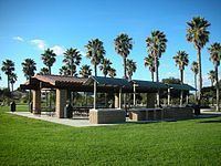
The park is located along the California Coastal Trail and the Pacific Coast Bicycle Route. The park includes palm tree lined pathways and a bike/walking path connecting the communities of Oxnard Shores and Channel Islands Beach. There is also an easy bike/walking connection to Channel Islands Harbor. Oxnard Beach Park includes two spacious barbecue areas with a capacity of 200 occupants, each with a public sink, table, and a large grill. Activities include beachcombing, walking, and ocean swimming. The park was designed to protect the sand dunes between the beach and grass picnic area.
History
Jean Harris persuaded city of Oxnard leaders to adopt a grand vision in the creation of this park. The State of California initially purchased a 26-acre site for the park in 1979. The developer of an adjacent residential with a hotel site dedicated an additional 36 acres, giving the park its present size of 62 acres. With the adoption of an operating agreement between City and State in December 1983, plans were developed for this park that was initially called Oxnard State Beach. The park was transferred to City of Oxnard in 1998.