
Country United States Owned by County of Ventura Size of harbor 166 acres Opened 1960 | Type of harbor Artificial Available berths 2,150 | |
 | ||
Owner Ventura County, California Similar Channel Islands Maritime, Oxnard Beach Park, Anacapa Island, McGrath State Beach, Gull Wings Children's Museum | ||
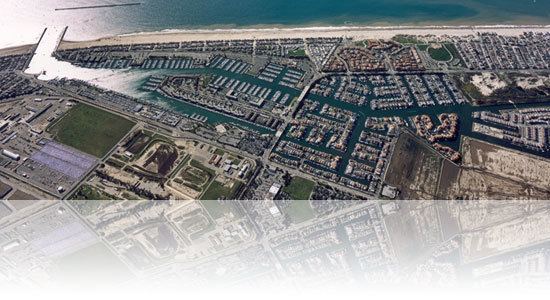
Drone view of channel islands harbor
Channel Islands Harbor is a combined shore-protection project and small craft harbor located at the southern end of the Santa Barbara Channel in Oxnard, California. It is the fifth largest harbor for small-craft recreation in the state of California and is a waterfront resort, recreation, and dining marketplace. Recreational activities include diving, boat charters, sea kayaking, sportfishing, and whale watching (gray whales January through early April; blue and humpback whales July to September).
Contents
- Drone view of channel islands harbor
- Map of Channel Islands Harbor Hollywood CA 93035 USA
- Channel islands harbor
- History
- Neighborhood and destinations
- References
Map of Channel Islands Harbor, Hollywood, CA 93035, USA
The horse-shoe shaped harbor contains 166 acres (0.67 km2) of water surrounded by 126 acres (0.51 km2) of land and supports more than 2,500 vessels, four yacht clubs, and nine full-service marinas. It is a point of departure for the five Channel Islands, the closest of which is Anacapa Island. The Ventura County Maritime Museum is located within the harbor and offers a regularly rotating exhibit, maritime-themed art, and model ships. Water taxis are available to drop diners and shoppers at various docks within the harbor. Every three years the harbor is host to the Channel Islands Tall Ships Festival which includes between two and five large sailing vessels and draws thousands of visitors.
Channel islands harbor
History
The US Army Corps of Engineers formed the harbor in 1960 by scooping out sand dunes and wetlands and depositing the surplus sand at the nearby beaches of Port Hueneme. The sand trap at the harbor entrance was designed to retain sand that otherwise might be diverted into the ocean due to the impacts of the construction of the Port of Hueneme. The sand was to be regularly dredged and placed on Hueneme Beach which suffers erosion due to the port blocking the littoral drift of sand.
Neighborhood and destinations
The harbor waters connect to the north with Mandalay Bay, a residential 129-unit waterfront development built by a company called Shamrock/ Voss, a joint venture of Shamrock Holdings Inc. of Burbank and Voss Construction Co. Inc. of Oxnard in 1987. The development is arranged in six tracts of single-family homes and townhouses standing on reinforced concrete bulkheads along a series of short navigable canal-like waterways. Between 1950 and 1981 Mandalay Bay was a permitted oil field waste disposal site which caused the release of numerous hazardous chemicals. The records of what was dumped were subsequently lost, resulting in calls for an investigation and millions of dollars in lawsuits from home buyers who were told the area was safe for habitation.
The Channel Islands Boating Center opened in 2013.