
Official name Oxbow Dam Height 53 m Surface area 4.654 km² | Opening date 1961 Creates Oxbow Reservoir Opened 1961 Total capacity 71.79 million m³ | |
 | ||
Catchment area 73,300 square miles (190,000 km) Similar | ||
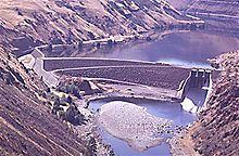
Oxbow Dam is a hydroelectric run-of-the-river rockfill dam on the Snake River on the Idaho-Oregon border, in Hells Canyon (river mile 273). It is part of the Hells Canyon Project that also includes Hells Canyon Dam and Brownlee Dam, built and operated by Idaho Power Company.
Contents
Map of Oxbow Dam, Council, ID 83612, USA
The dam's powerhouse contains four generating units with a total nameplate capacity of 190 megawatts (250,000 hp).
Lacking passage for migrating salmon, the three Hells Canyon Project dams blocked access by anadromous salmonids to a stretch of the Snake River drainage basin from Hells Canyon Dam up to Shoshone Falls, which naturally prevents any upstream fish passage to the upper Snake River basin.
HeliportEdit
Oxbow Heliport (FAA LID: OR83) is a private 100-by-100-foot (30 by 30 m), turf heliport owned by Idaho Power Company.