
Population 228 (2011) Civil parish Oxborough Area 13.24 km² | OS grid reference TF742012 Sovereign state United Kingdom Local time Tuesday 9:43 PM | |
 | ||
Weather 13°C, Wind SW at 24 km/h, 71% Humidity | ||
Oxborough is a village and civil parish in the English county of Norfolk. It covers an area of 13.024 km2 (5.029 sq mi) and had a population of 240 in 106 households in the 2001 census, reducing to a population of 228 in 111 households at the 2011 Census. For the purposes of local government, it falls within the district of Breckland.
Contents
Map of Oxborough, UK
Oxborough is famous for its church, and the manor house Oxburgh Hall. The Oxborough dirk, a Bronze Age ceremonial oversize dagger was discovered nearby in 1988. It was acquired for the nation and is now on display in the British Museum.
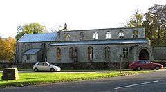
St. John's church
In 1948, the tower and spire of St. Johns collapsed onto the church below, destroying the south side of the nave. This was due to the weight of the bells, coupled with high winds. The south chapel contains a rare terracotta tomb, which was undamaged in the collapse. This tomb is unique in England, and is evidence of the Roman Catholicism of the Bedingfeld family.
Oxburgh Hall
Oxburgh Hall is the ancient ancestral home of the Bedingfeld family, and is now owned by the National Trust.