
Time zone WET (UTC+0) Population 6,916 (2004) | Local time Tuesday 3:50 AM Province Al Haouz Province | |
 | ||
Weather 12°C, Wind N at 6 km/h, 67% Humidity | ||
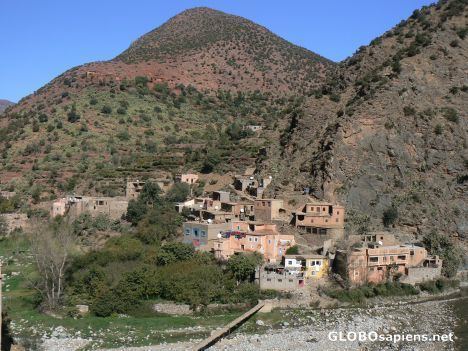
Ouirgane is a small town and rural commune in Al Haouz Province of the Marrakesh-Tensift-El Haouz region of Morocco. At the time of the 2004 census, the commune had a total population of 6916 people living in 1281 households. It is a Berber village.
Contents
Map of Ouirgane, Morocco
Geography
Ouirgane is situated in the High Atlas mountains in the heart of the Toubkal National Park at about 1,000 metres (3,300 ft) above sea level. By road it is located 14 kilometres (8.7 mi) southwest of Asni and 65 kilometres (40 mi) south of Marrakesh along the S501 road. The Oued Nfis River flows through the valley of the commune. The village itself lies on the eastern bank of the reservoir and barrage which dams the Oued Nfis river. The village is set amongst olive trees.
Landmarks
Ouirgane has a souq noted for its Berber pottery the Tin Mal Mosque, a ruined kasbah, and several salt mines in the vicinity. There are also two notable hotels with facing gardens; a stream near the hotels "drains the western face of Jbel Toubkal". La Roseraie hotel has horse-riding facilities to accommodate the many tourists who visit during the summer months; it also has a health center above the mineral stream. The Auberge au Sanglier qui Fume is a hunter's lodge. Tagadirt n'Bour is constructed of drystone walls and is located 4 kilometres (2.5 mi) south of the village.