
District Oudong Local time Tuesday 9:13 AM | ||
 | ||
Weather 28°C, Wind N at 10 km/h, 67% Humidity | ||
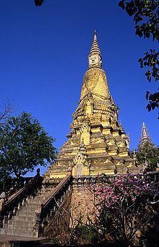
Oudong (Khmer: ឧដុង្គ) (also romanized as Udong or Odong) is a town in Cambodia, situated in the north-western part of Kampong Speu Province. Located at the foothill of the mountain Phnom Udong, about 40 km northwest of the modern capital Phnom Penh, Oudong was royal residence and Cambodia's capital for more than 250 years until 1866. A monumental royal necropolis of sovereigns of several centuries is scattered on top the prominent bisected mountain, which runs from the southeast to the northeast.
Contents
- Map of Oudongk Cambodia
- Asian travel monkey s lives in oudong mountain welcome to 2016 cambodia top 10s
- Etymology
- History
- Folklore
- World Heritage Status
- References
Map of Oudongk, Cambodia
Asian travel monkey s lives in oudong mountain welcome to 2016 cambodia top 10s
Etymology
The city's name is derived from the Sanskrit word "uttuṅga" (Sanskrit: उत्तुङ्ग), meaning tall, which probably refers to the mountain. As it had gained religious merit and significance it might have undergone extension towards: "great" or "supreme".
History
Oudong was founded by King Srei Soryapor in 1601, after the abandonment of Longvek. Under the reign of King Ang Duong (1841-1850), he constructed canals, terraces, bridges and erected hundreds of pagodas in this region. Oudong was later abandoned by King Norodom in 1866 in favor of Phnom Penh.
From 1618 until 1866 it was formally called Oudong Meanchey, home to a succession of kings deposed from the former capital of Lovek by the invading Thais. In 1866, it was abandoned by King Norodom, taking his royal court along with him to the current capital, Phnom Penh. It was extensively damaged by the Khmer Rouge in 1977, along with the other temples, monuments, and religious structures there.
Folklore
Legend has it that in the Arthaross Temple (Temple of Eighteen Points, from Pali: अट्ठारस aṭṭhārasa, eighteen ), the Buddha located here faces north instead of the traditional direction of east, symbolizing a testimony to the strength and power of the ancient Khmer kingdom.
In the 18th century, locals say, a Chinese emperor sent his people out across Asia to identify potential threats. When they came to Oudong, they saw a mountain shaped like a naga, with a cavern on top of the Arthaross end, and they observed the wealth and power of Khmer society. The Chinese told their emperor that the Khmers were already a powerful race, and should a naga appear through the cavern of Arthaross, they would be strong enough to rule the world.
The Chinese emperor did not want this, nor did he want a war. Instead, he asked the Khmer king if he could build a temple above the cavern, with the Buddha's face towards China in order to protect his empire. This was named the Arthaross temple, which means "eighteen corners", because there are 18 points, or corners, built into the temple's structure.
Henri Mouhot: "Travels in the Central Parts of Indo-China" 1864:
World Heritage Status
This site was added to the UNESCO World Heritage Tentative List on September 1, 1992 in the Cultural category.