
Basin size 3,948 km (1,524 sq mi) | ||
 | ||
River mouth | ||
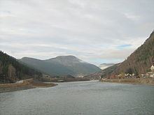
The Otta River flows through the Ottadal valley in the municipalities of Skjåk, Lom, Vågå, and Sel in Norway.
Contents
Map of Otta, Norway
The Otta River begins in Skjåk municipality and flows into lake Vågåvatn. Exiting Vågåvatn at Vågåmo, it continues its journey through the Ottadal, leaving the municipality of Vågå to meet the Gudbrandsdalslågen at the town of Otta in the municipality of Sel.
The watershed of the Otta drains an area of 3,948 square kilometres (1,524 sq mi).
The Otta River is known for rafting. The rafting season begins in mid-May and lasts until the end of September.
Name
The name of the river is probably derived from the Norse verb ótta 'scare, terrify'. The water of the river comes from glaciers, and the flooding of the river can be strong and fierce.
References
Otta (river) Wikipedia(Text) CC BY-SA