
Area 616.3 km² | Car plates TOS | |
 | ||
Gminas Total 6 (incl. 1 urban)Ostrowiec ŚwiętokrzyskiGmina BałtówGmina BodzechówGmina ĆmielówGmina KunówGmina Waśniów University Wyższa Szkoła Biznesu i Przedsiębiorczości w Ostrowcu Świętokrzyskim Clubs and Teams KSZO Ostrowiec Świętokrzyski, AZS KSZO Ostrowiec Świętokrzyski Points of interest JuraPark Bałtów, Bałtowski Kompleks Turystyczny, Krzemionki, Żywe Muzeum Porcelan, Odwrócony dom | ||
Ostrowiec County (Polish: powiat ostrowiecki) is a unit of territorial administration and local government (powiat) in Świętokrzyskie Voivodeship, south-central Poland. It came into being on January 1, 1999, as a result of the Polish local government reforms passed in 1998. Its administrative seat and largest town is Ostrowiec Świętokrzyski, which lies 56 kilometres (35 mi) east of the regional capital Kielce. The county also contains the towns of Ćmielów, lying 10 km (6 mi) south-east of Ostrowiec Świętokrzyski, and Kunów, 9 km (6 mi) west of Ostrowiec Świętokrzyski.
Contents
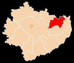
Map of Ostrowiec County, Poland
The county covers an area of 616.33 square kilometres (238.0 sq mi). As of 2006 its total population is 116,179, out of which the population of Ostrowiec Świętokrzyski is 73,937, that of Ćmielów is 3,172, that of Kunów is 3,127, and the rural population is 35,943.
Neighbouring counties
Ostrowiec County is bordered by Lipsko County to the north, Opatów County to the south, and Kielce County and Starachowice County to the west.
Administrative division
The county is subdivided into six gminas (one urban, two urban-rural and three rural). These are listed in the following table, in descending order of population.