
District Göttingen Time zone CET/CEST (UTC+1/+2) Population 23,993 (31 Dec 2008) | Elevation 220 m (720 ft) Postal codes 37520 Local time Monday 6:39 PM | |
 | ||
Weather 15°C, Wind SE at 10 km/h, 33% Humidity Points of interest ALOHA Aqualand Waterpar, Alte Burg, Museum im Ritterhaus, Industriedenkmal Eulenburg, Lichtenstein Cave | ||
For the town in East Prussia formerly called Osterode, see Ostróda.
Contents
- Map of 37520 Osterode am Harz Germany
- Water
- Districts
- Local council
- Mayor
- Twinned towns
- Museums
- Architecture
- Recreation
- Transport
- Educational institutions
- Notable natives
- References
Map of 37520 Osterode am Harz, Germany
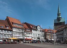
Osterode am Harz often simply called Osterode, is a town in south-eastern Niedersachsen on the south-western edge of the Harz mountains. It is the seat of government of the district of Göttingen. Osterode is located on the German Timber-Frame Road.
Water
The Söse river flows through the town from the Sösetalsperre reservoir lake about 5 km upstream. The dam was built in 1931 and has a capacity of 25.5 million m³. The Harzwasserwerke water company pipes drinking water as far away as Bremen.
Districts
The following districts (mainly surrounding villages) are part of the borough of Osterode am Harz, with populations in brackets (as of 1 July 2012):
Local council
The Gemeinderat or council of Osterode has 34 members:
and one Bürgermeister (mayor). (local election on 11 September 2011)
Mayor
Klaus Becker has been Bürgermeister (mayor) of Osterode since 1 June 2004. He has no party affiliation.
Twinned towns
Museums
The Museum im Ritterhaus displays documents from Osterode's history from the Middle Ages to the recent past, as well as occasional temporary exhibitions.
The Lichtenstein Cave is an archaeological site near Dorste, in the western part of the municipality. Two inhabitants of the village Nienstedt am Harz, 2 km north of the cave, have the same rare DNA pattern as that found in the skeletal material of a man whose bones were found in the Lichtenstein Cave dating to about 1000 BC.
Architecture
In the environs of Osterode there are several castle ruins, and Lichtenstein Castle between Dorste and Förste.
The town granary built between 1719 and 1722 is one of the most imposing buildings, built to supply the mining villages in the Upper Harz with grain. Today after a comprehensive renovation it has become the town hall.
Recreation
Osterode is the starting point of the 100 km long Harzer Hexenstieg, a hiking trail to Thale.
Transport
The B 243 federal route, built as a divided highway, is the main western link between the northern and southern Harz area. B 241 and B 498 link Solling to the eastern Harz.
Osterode lies on the Herzberg–Seesen railway, with services to Brunswick. In November 2004 the city gained two new stations at a cost of about 1 million Euro, replacing two previous halts and providing a more central access to public transport.