
Surface elevation 278 m | ||
 | ||
Location Regional District of Okanagan-Similkameen, British Columbia, Canada / Okanogan County, Washington, United States Similar Sẁiẁs Provincial Park, Spotted Lake, Nk'Mip Desert Cultural, Rattlesnake Canyon, Desert Centre Osoyoos | ||
Osoyoos Lake is a lake located in British Columbia and Washington. Osoyoos is derived from the word sẁiẁs meaning "narrowing of the waters" in the local Okanagan language (Syilx'tsn).
Contents
Map of Osoyoos Lake
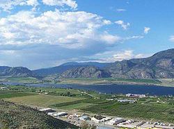
Located on the lakeshore are the towns of Osoyoos, British Columbia and Oroville, Washington. The lake's maximum elevation is 912.78 ft (278.22 m), while its minimum elevation is 909.46 ft (277.20 m). The 62-year average discharge into the Okanogan River at Oroville is 683 cu ft/s (19.3 m3/s). Maximum discharge in 2004 was 1,340 cu ft/s (38 m3/s). Oroville's Osoyoos Lake State Park is located on its shore.
An international lakeEdit
Osoyoos Lake and its outlet and primary inflow, the Okanogan River (known as the Okanagan River in Canada), are subject to international water-sharing agreements governed by the International Joint Commission as part of the Columbia Basin. The authority responsible for overseeing the IJC agreements is the International Osoyoos Lake Board of Control, composed of appointees from Environment Canada, the BC Ministry of Water, Land Air Protection, the US Army Corps of Engineers, the US Geological Survey, and private consultants.