
Airport type Public 1/19 6,020 Code OVE Phone +1 530-538-2401 | Operator City of Oroville Elevation AMSL 192 ft / 58.5 m 6,020 1,835 Elevation 58 m | |
 | ||
Address 225 Chuck Yeager Way, Oroville, CA 95965, USA Similar Oroville Muni, Police Departme, Butte County Jail, Oroville Chamber of Comm, Communi Disease & Emergen | ||
Oroville municipal airport ove landing rwy 19
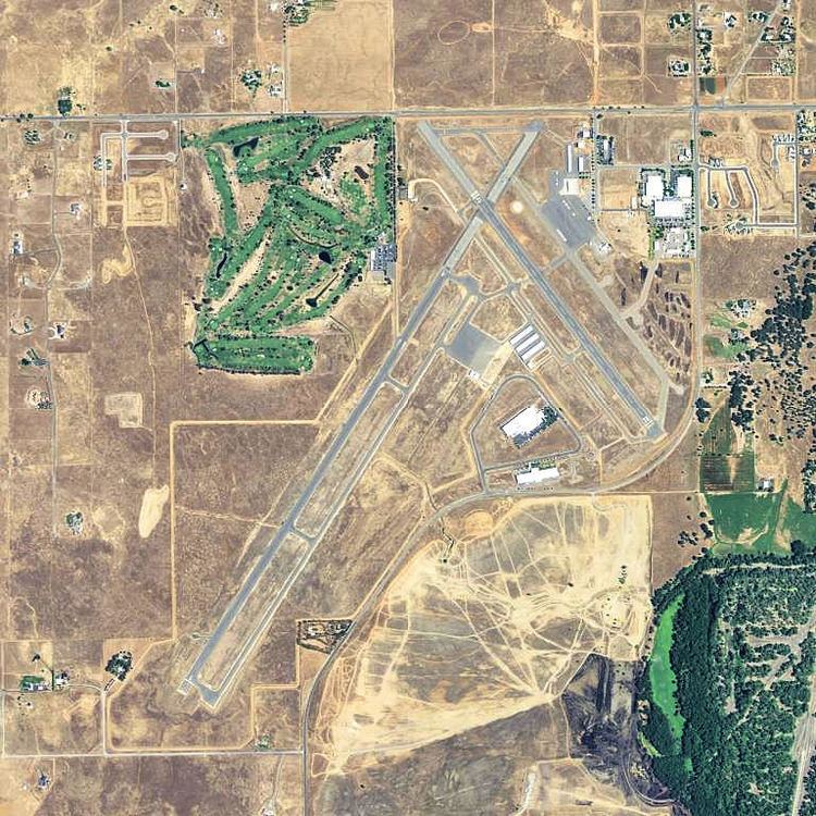
Oroville Municipal Airport (IATA: OVE, ICAO: KOVE) is 3 miles (5 km) southwest of Oroville in Butte County, California.
Contents
Oroville municipal airport ove night landing rwy 12
Facilities
The airport covers 920 acres (3.7 km2) and has two runways:
Table Mountain Aviation is part of the Oroville Municipal Airport.
There are three parallel taxiways:
Three main apron areas exist on the airfield. The largest apron area is around the Table Mountain Aviation FBO buildings. The FBO apron area is home to 38 tie-downs as well as the fuel tanks and provides access to Taxiway R to the west of the apron and Taxiway S to the north of the apron. The second largest apron area is in the midfield area, south of Runway 19. This area has 76 tie downs. The third apron area is east of the Table Mountain Golf Course and has space for 5 tie downs, ideal for golfers that fly to the Airport.
History
In 1936, the City of Oroville acquired 188 acres (0.76 km2) of grazing land for a municipal airport. During 1941, the city and the Works Project Administration (WPA) extended the runways and increased the total area to 428 acres (1.73 km2).
In 1942 the War Department leased the Oroville Municipal Airport and renamed it Oroville Army Air Field (AAF). That same year the Army purchased an additional 381.98 acres (1.5458 km2) of land for expansion of the field and construction of a cantonment area. Once operational, it served as a fighter group training installation from spring of 1943 through early summer 1944. Two fighter groups rotated through Oroville AAF: the 357th Fighter Group (fighter group of famed pilots Chuck Yeager and Bud Anderson) and the 369th Fighter Group. Aircraft present at the field were identified as the Bell P-39Q Airacobra, North American P-51B/C/D Mustangs, and possibly the North American A-36 Apache, the ground attack version of the P-51.
Layout plans of the former Oroville AAF dated 1944 indicate a Bomb Storage Area west of the two runways and a skeet range between the southern extents of the runways. Fueling pit boxes were located along former Taxiways A (running parallel to runway 12/30) and C (connecting the southernmost ends of runways 1/19 and 12/30). A 1947 Inventory Report of Buildings and Structures states that bombs were stored in earth revetments.
In 1945 Oroville AAF was listed as “temporarily inactive” under assignment to Air Technical Service Command and was later classified as surplus. In 1946 the War Assets Administration (WAA) assumed custody of the site and on 21 May 1947, the WAA terminated the U.S. Army’s lease with the City of Oroville and returned ownership to civil authorities.