
 | ||
From 1890 through 2006, the Orleans Levee Board was the body of commissioners that oversaw the Orleans Levee District (OLD) which supervised the levee and floodwall system in Orleans Parish, Louisiana. The role of the OLD has changed over time but the primary purpose of the board was to protect New Orleans from flooding, and to protect and operate the equipment placed and assigned for that purpose.
Contents
In the wake of the catastrophic levee failures in New Orleans during Hurricane Katrina, two new regional flood protection authorities were created to replace the multiple parochial levee boards, including Orleans Parish's Levee Board. Most of the Orleans Levee District now falls under the jurisdiction of the Southeast Louisiana Flood Protection Authority - East, charged with the oversight of all flood-protection infrastructure for Greater New Orleans on the East Bank of the Mississippi River. The Southeast Louisiana Flood Protection Authority - West possesses the same metro-wide jurisdiction for the West Bank of the Mississippi, and it includes that portion of the Orleans Levee District on the West Bank (i.e., Algiers).
Until the end of 2006, the Orleans Levee Board was a major governmental entity which functioned independently of municipal government in and around Orleans Parish. (Orleans Parish is coextensive with the city of New Orleans; their boundaries are one and the same).
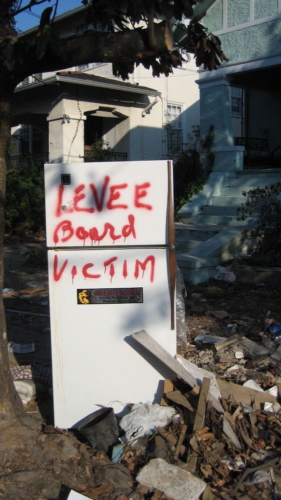
When Hurricana Katrina arrived in New Orleans, the OLB enjoyed ‘relatively cushy finances, pumped millions into road projects, bridges, a marina and ill-fated studies of everything from a movie studio to a fiber-optic network to a man-made island near Lake Pontchartrain’s south shore’. This would seem to describe how far-reaching the OLB was in its commercial interests, and it is clear that members of the OLB attended meetings to discuss issues not specifically related to engineering and flood protection. It also was becoming apparent that perhaps a different form of levee board governance might be more appropriate for a major marine terminal like New Orleans. Nevertheless, the issue of whether the members of the OLB Engineering Committee acted incompetently or negligently has not been conclusively demonstrated or proven.
History
The pre-Katrina Orleans Levee District (OLD), governed by the Orleans Levee Board (OLB), owned considerable assets, mainly real estate, a peculiarity that stems from its history. The Orleans Levee District was created by the Louisiana legislature in 1890 for the purpose of protecting the low-lying city of New Orleans from floods. At that time, communities along the Mississippi River were largely in charge of creating their own levees to protect themselves, as no unified levee system existed. Most neighboring parishes had (and some still have) similar parochial levee boards. In the early twentieth century, the OLD reclaimed a portion of Lake Pontchartrain, a 24-mile wide lake north of New Orleans. The OLD developed the land and sold it to raise money to build and improve levees. Starting in the 1920s, the Board undertook a massive flood-protection initiative involving the construction of a stepped seawall several hundred feet north of a portion of the existing south shore of Lake Pontchartrain. The intervening area was filled to several feet above sea level and was to serve as a "super levee" protecting the city from the Lake's storm surge.
The Lake Vista, Lake Oaks, Lake Terrace, East and West Lakeshore subdivisions and other property between Robert E. Lee Blvd and Lake Pontchartrain are all examples of the OLB's developed properties.
In 1924, the state legislature authorized the OLB to acquire 33,000 acres (130 km²) of land on the east bank of the Mississippi River about 50 miles (80 km) south of New Orleans in order to build the Bohemia Spillway between the River and the Gulf of Mexico. (1924 La. Acts 99). Approximately half of this land was public property transferred from the state; the other half was either expropriated, or purchased under threat of expropriation, from private owners according to a legal finding. (1928 La. Acts 246; 1942 La. Acts 311).
In the aftermath of the Great Mississippi Flood of 1927, the U.S. Congress gave the United States Army Corps of Engineers supervision and control over the design and construction of flood-control infrastructure throughout the Mississippi River Valley.
In 1934, New Orleans Lakefront Airport opened on land dredged from Lake Pontchartrain by the Levee Board, part of a larger "lakefill" land-reclamation project initiated to construct a super levee for the protection of the northern perimeter of the city. The airport was originally named "Shushan Airport" after Orleans Levee Board president Abraham Lazar Shushan; it was renamed "New Orleans Airport" after Shushan's indictment for corruption in the Louisiana Scandals of the late 1930s.
Governor Jimmie Davis, in his second term from 1960 to 1964, named the New Orleans attorney Gerald J. Gallinghouse as the president of the levee board. In that capacity, Gallinghouse delivered more than 300 speeches warning of the need to be prepared for weather disasters, another of which was on its way, Hurricane Betsy.
After extensive flooding during Hurricane Betsy in 1965, Congress ordered the U.S. Army Corps of Engineers henceforth to design and build flood protection in the Lake Pontchartrain and Vicinity Hurricane Protection Project. The OLB became the local sponsor, and its duties regarding flood protection were now limited to collecting 30% cost-share for project design and construction and maintaining the completed structures. Despite Congress’s mandate that the Corps now had the authority to design/build flood protection, the OLB still retained extensive assets which had to be managed. A 2002 lawsuit detailed the Orleans Levee Board's considerable independent financial means.
From the Levee Board's Legal Statement at trial:
"With regard to the more general question of the levee district's budget, the Orleans Levee District receives very little funding from the state. The levee district generates its own revenues from the Lakefront Airport, a casino, leases of property, fees from boat slips and marinas, and taxes. The district also receives income from various investment accounts currently worth $57 million. The levee board does not dispute these facts. At oral argument, counsel for the levee board pointed out that the district receives some state funds, even though they are usually in the form of capital outlays dedicated to specific projects. Because the state funds are already earmarked for other purposes, the state monies cannot be used to pay a judgment against the levee district. See Hudson, 174 F.3d at 688-89."Orleans Levee Board and Hurricane Katrina
After Hurricane Katrina, in a context of shock, chaos and confusion, the Orleans Levee Board found itself at the center of the greatest crisis ever to face the city of New Orleans. Multiple levee and floodwall breaches in the Industrial Canal, the 17th Street Canal, and the London Avenue Canal resulted in the flooding of 80% of the city. The flood is believed to have directly caused over 1,400 deaths; destroyed or severely damaged homes, businesses, and property in the majority of the city.
Investigations after the disaster revealed that the design of the levee and floodwall system, designed and built by the U.S. Army Corps of Engineers, had profoundly inadequate design and construction specifications.
What is evident from the project record is that the Army Corps recommended raising the canal floodwalls for the 17th Street Canal, but recommended gated structures at the mouths of the Orleans and London Avenue Canals because the latter plan was less expensive. The OLB convinced Congress to pass legislation that required the Corps to raise the floodwalls for all three canals. Furthermore, the Corps, in a separate attempt to limit project costs, initiated a sheet pile load test (E-99 Study), but misinterpreted the results and wrongly concluded that sheet piles needed to be driven to depths of only 17 feet (1 foot ¼ 0.3048 meters) instead of between 31 and 46 feet. That decision saved approximately $100 million, but significantly reduced overall engineering reliability.
Changes to National and State Policy
After the levee failures, the immediate assumption was that the OLD commissioners were not engaged in flood protection. This was reinforced by corps spokespersons who repeatedly told a story of local levee board officials who “forced” the corps to build the system that failed. As revealed in an August 2015 article in the official journal of the World Water Council, the story is untrue, and responsibility for the levee failures belongs to the corps. Nonetheless, in the context of haste confusion, there were calls for the elimination of the Orleans Levee Board and other local boards.
During a special session of the Louisiana Legislature, a bill submitted by Sen. Walter Boasso (D-Arabi) was passed into law, which consolidated the levee boards of various parishes within Greater New Orleans. The new legislation was intended to (1) remove distractions, (2) replace parochial flood control with regional flood control, and (3) require commissioners to have professional expertise including hydrology, construction engineering and civil engineering.
The law created two new regional levee boards, Southeast Louisiana Flood Protection Authority-East and Southeast Louisiana Flood Protection Authority-West, separated by the Mississippi River. The Orleans Levee Board ceased to exist on January 1, 2007. The new regional flood-protection authorities assumed control of the Board's flood-protection infrastructure. Lakefront Airport, the marinas (except for the city-owned Municipal Yacht Harbor), Lakeshore Drive, and the lakefront park system (except for West End Park, administered by New Orleans' Parks and Parkways Department) are now operated and maintained by the Louisiana State Division of Administration Non-Flood Protection Asset Management Authority.
Investigative studies completed after the legislation’s passage revealed no causal link between the pre-Katrina levee boards and the flooding. Nonetheless, the new levee boards are very useful. To the extent legally possible and within budget, the East and West Levee Authorities are checking the corps’ general plans. They are well focused, have relevant expertise and may catch egregious planning and/or design errors.”
The levee breach event was a pivotal moment in American history. The nation took a different path due to the flooding event. The myriad changes to national policy as a result of this lynchpin moment include, but are not limited to, the following: Nationwide assessment of levees, First-ever National Levee Safety Act, National Flood Risk Management Program, Reform of the Army Corps of Engineers and Changes in Levee Building by the Corps.
Since fifty-five percent of American people lives in counties protected by levees, this means the majority of the national population are safer.