
Existed: 1935 – present Length 58.69 km | Constructed 1935 | |
 | ||
Oregon Route 219 (also known as part of the Hillsboro-Silverton Highway No. 140 (see Oregon highways and routes)) is an Oregon state highway which runs between the cities of Hillsboro and Woodburn, Oregon, in the United States. The Hillsboro-Silverton Highway continues further south to Silverton, signed as OR 214. The highway mainly serves local residents and agricultural traffic; despite its proximity to the Portland area it lies outside the Portland Urban Growth Boundary (except for its northern terminus in Hillsboro) and so maintains its character as a country road.
Contents
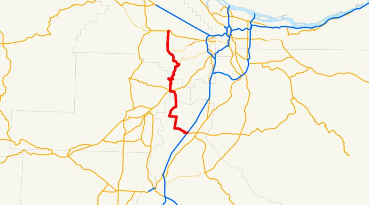
Map of OR-219, Oregon, USA
Route description
OR 219's southern terminus is at the junction with Interstate 5 and OR 214 in the city of Woodburn. (A single diamond interchange serves both OR 219 and OR 214 from the freeway; OR 219 leads west of the interchange and OR 214 heads east.) After passing a collection of shopping malls and motel chains around the Woodburn exit, OR 219 starts winding its way through the Marion County countryside, heading in a northwesterly direction. As the area is primarily farmland, the alignment of OR 219 heads west for a while, then turns north, then turns west again; the route contains numerous 90-degree turns.
The next city encountered is the city of St. Paul. From St. Paul, the highway then heads due north, parallel to (but at some distance from) the Willamette River. At this point the road is known as the St. Paul Highway. It turns west after the intersection with McKay Road, and after a four-way intersection providing access to Champoeg State Heritage Area, the route crosses the Willamette River. Soon after crossing the river, the highway enters the city of Newberg.
In Newberg, the route joins (and overlaps) OR 99W along the Pacific Highway West No. 1W, and the combined route then heads westward into the city center (when one travels on the concurrent section, one is simultaneously heading north on OR 219 and south on OR 99W, or vice versa). In downtown Newberg, the route enters a one-way couplet; and then OR 219 splits apart from OR 99W again, and heads north.
Immediately north of Newberg, the route enters a steep, narrow, twisty section as it climbs out of the Willamette Valley into the hills overlooking the town. Soon the road levels out again as OR 219 descends into the Tualatin Valley. The next major town is Scholls, where the route intersects with OR 210. Keeping on OR 219, one then heads in a general northwesterly direction, running parallel to the western bank of the Tualatin River. Just northwest of the intersection with OR 210 is Brown's Corner, followed by the 90 degree turn at the Midway Curve. The state plans to re-work those curves to improve safety.
After OR 210, the next major route encountered is OR 10, just west of Farmington. About five miles (8 km) after that, OR 219 enters the city of Hillsboro as it crosses the Tualatin River and passes by Jackson Bottom Wetlands Preserve. Entering downtown Hillsboro, OR 219 becomes South 1st Street before ending at the intersection with Oregon Route 8, the Tualatin Valley Highway. Mile marker numbering begins here as zero, with numbers increasing as the road stretches to the south.
History
In 1989, Washington County renamed the road in the county from Oregon 219 to Hillsboro Highway. This was part of an effort to improve response times by emergency services.
One significant alignment change occurred during the 1990s. It used to be the case that OR 219, rather than running between St. Paul and Woodburn, instead continued south along French Prairie Road and River Road to Salem, Oregon, where it terminated in the northern part of Salem, near the Keizer city line at an intersection with the Salem Parkway (and, prior to the parkway's construction, down Broadway and High Streets to the corner of High Street and the Marion/Center Street street couplet downtown, where Highways 22 and 99E used to run). An extension of OR 214 connected Woodburn with St. Paul. However, that section of OR 219 is no longer marked as a state route. Many maps (including Yahoo Maps) still show the old alignment of OR 219.
A proposed future extension of OR 18 (the Newberg-Dundee Bypass) will intersect Oregon Route 219 south of Newberg if it is constructed.
Major intersections
Note: mileposts do not reflect actual mileage due to realignments.