
Airport type Public 17/35 5,399 1,646 Asphalt Elevation 59 m | Elevation AMSL 195 ft / 59 m 5,399 1,646 Code OGB Phone +1 803-534-5545 | |
 | ||
Address 1811 Airport Rd, Orangeburg, SC 29115, USA Similar Columbia Metropolit Airport, Claflin University, Hampton Inn & Suites Or, Baymont Inn & Suites Or, Fairfield Inn by Marriott O | ||
Boeing stearman taking off at orangeburg municipal airport
Orangeburg Municipal Airport (IATA: OGB, ICAO: KOGB, FAA LID: OGB) is a city owned, public use airport located two nautical miles (4 km) south of the central business district of Orangeburg, a city in Orangeburg County, South Carolina, United States. It is included in the National Plan of Integrated Airport Systems for 2011–2015, which categorized it as a general aviation facility. The airport does not have scheduled commercial airline service.
Contents
- Boeing stearman taking off at orangeburg municipal airport
- Boeing stearman landing at orangeburg municipal airport
- Facilities and aircraft
- References
During World War II, the 58th Flying Training Detachment, operated by the Hawthorne School of Aeronautics, trained both U.S. and French airmen at what was Hawthorne Field. The detachment was supervised by the 29th Flying Training Wing.
Boeing stearman landing at orangeburg municipal airport
Facilities and aircraft
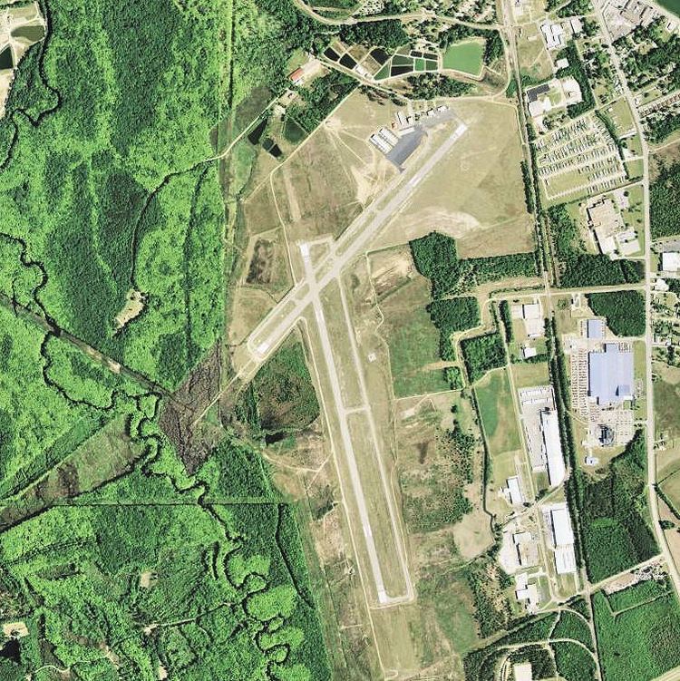
Orangeburg Municipal Airport covers an area of 300 acres (121 ha) at an elevation of 195 feet (59 m) above mean sea level. It has two asphalt paved runways: 17/35 is 5,399 by 100 feet (1,646 x 30 m) and 5/23 is 4,508 by 100 feet (1,374 x 30 m).
For the 12-month period ending August 12, 2011, the airport had 22,420 aircraft operations, an average of 61 per day: 99% general aviation, 1% air taxi, and <1% military. At that time there were 22 aircraft based at this airport: 73% single-engine and 27% multi-engine.