
Abbreviation OSGeo Type NGO | Founded at Chicago | |
 | ||
Motto Your Open Source Compass Founded February 4, 2006; 11 years ago (2006-02-04) Founders Arnulf Christl, Chris Holmes, Gary Lang, Markus Neteler, Frank Warmerdam | ||
The Open Source Geospatial Foundation (OSGeo), is a non-profit non-governmental organization whose mission is to support and promote the collaborative development of open geospatial technologies and data. The foundation was formed in February 2006 to provide financial, organizational and legal support to the broader Free and open source geospatial community. It also serves as an independent legal entity to which community members can contribute code, funding and other resources, secure in the knowledge that their contributions will be maintained for public benefit.
Contents
- Governance
- Projects
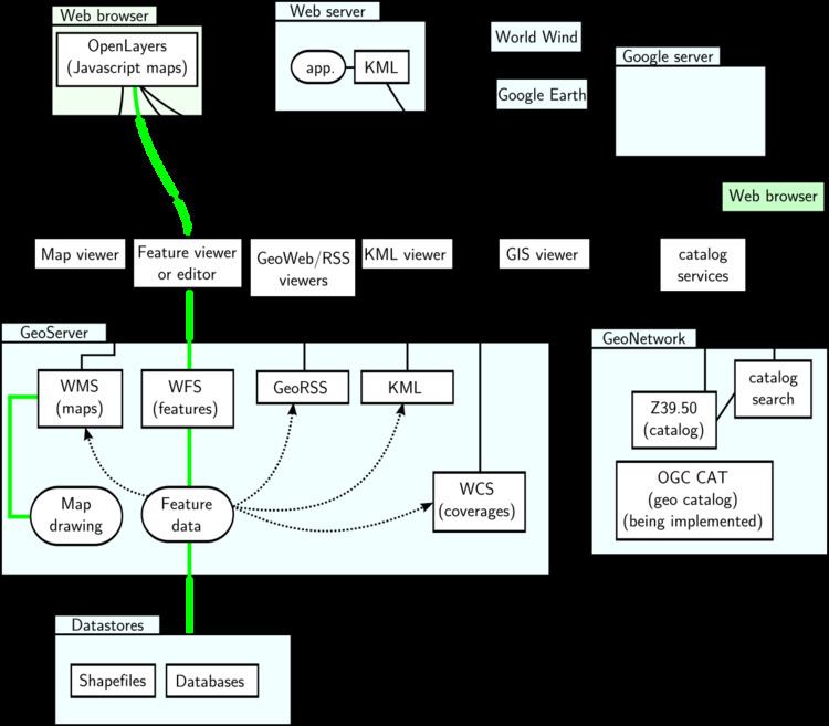
- Geospatial Libraries
- Desktop Applications
- Server
- Client
- Metadata Catalog
- Outreach Projects
- Retired Projects
- Events
- Community
- Sol Katz Award
- References
OSGeo draws governance inspiration from several aspects of the Apache Foundation, including a membership composed of individuals drawn from foundation projects who are selected for membership status based on their active contribution to foundation projects and governance.
The foundation pursues goals beyond software development, such as promoting more open access to government produced geospatial data and completely free geodata, such as that created and maintained by the OpenStreetMap project. Education and training are also addressed. Various committees within the foundation work on implementing strategies.
Governance
The OSGeo Foundation is community driven and has an organizational structure consisting of elected members and nine directors, including the president. Software projects have their own governance structure, by requirement. see FAQ. The OSGeo community collaborates via a Wiki, Mailing Lists and IRC.
Projects
OSGeo projects include:
Geospatial Libraries
Desktop Applications
Server
Client
Metadata Catalog
Outreach Projects
Retired Projects
Events
OSGeo runs an annual international conference called FOSS4G – Free and Open Source Software for Geospatial. Starting as early as 2006, this event has drawn over 900 attendees (2011) and is expected to bring in even more each year. It is the main meeting place and educational outreach opportunity for OSGeo members, supporters and newcomers - to share and learn from one another in presentations, hands-on workshops and a conference exhibition.
Community
The OSGeo community is composed of participants from everywhere in the world. As of August 2012, there were 19,160 unique subscribers to the more than 180 OSGeo mailing lists. As of September 2012, OSGeo projects were built upon over 12.7 million lines of code contributed by 657 code submitters including 301 that have contributed within the last 12 months.
Sol Katz Award
The Sol Katz Award for Geospatial Free and Open Source Software (GFOSS) is awarded annually by OSGeo to individuals who have demonstrated leadership in the GFOSS community. Recipients of the award will have contributed significantly through their activities to advance open source ideals in the geospatial realm.