
- summer (DST) CEST (UTC+2) Area 12.01 km² | Elevation 225 m Local time Saturday 11:03 AM | |
 | ||
Weather 10°C, Wind SW at 6 km/h, 57% Humidity | ||
Vlaky opatovice nad labem 13 6 2013
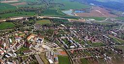
Opatovice nad Labem is a village in the Czech Republic, in Pardubice Region. It lies between the city of Pardubice and Hradec Králové. It has cca 2,500 inhabitants. Opatovice nad Labem is second largest village in Pardubice Region.
Contents
- Vlaky opatovice nad labem 13 6 2013
- Map of 533 45 Opatovice nad Labem Czechia
- Ice speedway m r opatovice nad labem 2017 by berny
- History
- Sights
- Education
- Traditional festivals and events
- References
Map of 533 45 Opatovice nad Labem, Czechia
Opatovice nad Labem was until recently known mainly for its large power station that was first activated in 1959. Now the village is especially known for commissioning one of the largest road junctions in the Czech Republic. Many tourist and cyclist trails pass through there. Near Opatovice nad Labem there are many quarries suitable for swimming and relaxation. The most used is, thanks to its clear water,the quarry called Opaťák.
Ice speedway m r opatovice nad labem 2017 by berny
History
Village Opatovice nad Labem has a very rich history. Archaeological research which was conducted here in the last decades, confirmed, that mild climate and fertile surroundings of the Labe (Elbe) riverhad been exploited by our ancient ancestors. The first record about the village comes from the year 1073. The record is from the foundation list of its church which was named the Opatovice Church and was burnt down in the 15th century.