
Last eruption 7351 BC | Topo map NTS 92.G/15 Elevation 1,736 m Prominence 86 m | |
 | ||
Volcanic arc/belt Canadian Cascade ArcGaribaldi Volcanic Belt Similar Cinder Cone, Round Mountain, Pyroclastic Peak, Vulcan's Thumb, Little Ring Mountain | ||
Hiking opal cone garibaldi provincial park the vancouver outdoor club
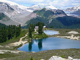
Opal Cone is a cinder cone located on the southeast flank of Mount Garibaldi in the Coast Mountains of British Columbia, Canada. It is the source of a 15 km long broad dacite lava flow with prominent wrinkled ridges. The lava flow is unusually long for a silicic lava flow.
Contents
- Hiking opal cone garibaldi provincial park the vancouver outdoor club
- Map of Opal Cone Squamish Lillooet D BC Canada
- References
Map of Opal Cone, Squamish-Lillooet D, BC, Canada
Opal Cone is a member of the Cascade Volcanoes, but it is located in the Garibaldi Ranges in the Coast Mountains and not in the Cascade Range proper.
References
Opal Cone Wikipedia(Text) CC BY-SA