
Traversed by SR 38 | Elevation 2,573 m | |
 | ||
Coordinates N 34° 11.533 W 116° 43.133 Similar Jenks Lake, San Gorgonio Mountain, San Bernardino National, Baldwin Lake, Rim of the World Scenic By | ||
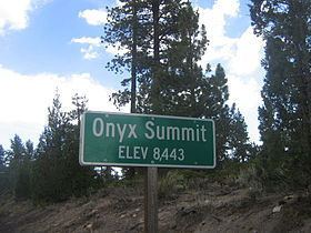
Onyx Summit is a mountain pass located in the San Bernardino Mountains in the southwestern part of San Bernardino County, California, United States. At an elevation of 8,443 ft. (2,573 m), it is the highest highway pass in Southern California. California State Route 38 traverses it at postmile 39.37 in the eastern part of San Bernardino National Forest.
Map of Onyx Summit, California 92305, USA
References
Onyx Summit Wikipedia(Text) CC BY-SA