
Elevation 2,650 m | Prominence 317 m Easiest route Hiking | |
 | ||
Similar Cucamonga Peak, Timber Mountain, Telegraph Peak, Mount San Antonio, Mount Islip | ||
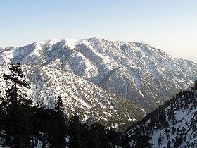
Ontario Peak, at 8,696 ft, is a high peak in the San Gabriel Mountains of California. Like its neighbor Cucamonga Peak, it is in the San Bernardino National Forest, and in the Cucamonga Wilderness. The peak is named for the nearby city of Ontario about 12 miles (19 km) due south, and first appeared in the General Land Office Forest Atlas in 1908.
Map of Ontario Peak, California, USA
The most accessible trailhead for hiking Ontario Peak is in Icehouse Canyon. Forest Service Trail 7W07 leads from here to Icehouse Saddle, from which the Ontario Peak Trail leads to the summit. This route is 13 miles (20.9 km) round trip, with 4,100 feet (1,200 m) of elevation gain.
References
Ontario Peak Wikipedia(Text) CC BY-SA