
Highest elevation 1,325 m (4,347 ft) Population 0 Elevation 1,325 m | Highest point Krenitsyn Ethnic groups Ainu (formerly) Area 425 km² | |
 | ||
Onekotan the lost island trailer fff15
Onekotan Island (Russian: Онекотан; Japanese 温禰古丹島; Onekotan-tō, occasionally Onnekotan-tō, Ainu: オネコタン or オネコタㇴ) is an uninhabited volcanic island located near the northern end of the Kuril Islands chain in the Sea of Okhotsk in the northwest Pacific Ocean. Its name is derived from the Ainu language for "large village".
Contents
- Onekotan the lost island trailer fff15
- Map of Onekotan Sakhalin Oblast Russia 694550
- onekotan island
- Geography and geology
- History
- Fauna
- References
Map of Onekotan, Sakhalin Oblast, Russia, 694550
onekotan island
Geography and geology
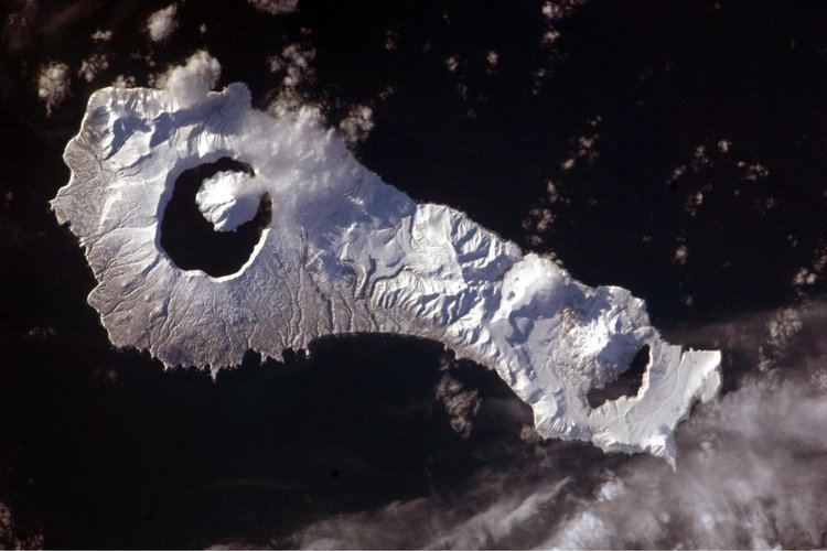
Onekotan is roughly rectangular, with a length of 42.5 kilometers, and a width ranging from 11 kilometers to 17 kilometers. It has an area of 425 km²
The island consists of two stratovolcanos connected by a relatively flat isthmus.
Onekotan Island is separated from the neighboring islands by the Fourth Kuril Strait, Yevreinov Strait, and Krenitsyn Strait. The neighboring islands are Makanrushi Island, with a 1170 meters volcanic peak, to the northwest of Onekotan Island; and Kharimkotan Island, with a 1210 meter high volcano, to the south.
Onekotan still has an active volcano with the most recent eruption, in 1952, forming a small lava dome on the island's coast.
History
Onekotan, with a number of shallow bays and sandy beaching providing landing points, was inhabited by the Ainu prior to European contact. It appears on an official map showing the territories of Matsumae Domain, a feudal domain of Edo period Japan dated 1644, and these holdings were officially confirmed by the Tokugawa shogunate in 1715. Subsequently, claimed by the Empire of Russia, sovereignty initially passed to Russia under the terms of the Treaty of Shimoda, but was returned to the Empire of Japan per the Treaty of Saint Petersburg in 1875 along with the rest of the Kuril islands. The island was formerly administered as part of Shimushu District of Nemuro Subprefecture of Hokkaidō. After World War II, the island came under the control of the Soviet Union, and is now administered as part of the Sakhalin Oblast of the Russian Federation.
Fauna
There are chars in Lake Chyornoye, one of the two lakes on Onekotan, located at the northern end of the island. In the spring and summer pigeon guillemot and Leach's storm petrel nest on the island.