
Country Namibia Capital | Area 26,551 km2 Governor Erkki Endjala | |
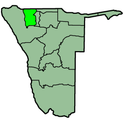 | ||
Map of Omusati Region
Omusati region is one of the fourteen regions of Namibia, its capital is Outapi. Mopani tree is the dominant species; the Makalani palms decrease rapidly westwards from the border with Oshana region. The change in vegetation type reflects ecological conditions forming a natural boundary between the two regions.
Contents
- Map of Omusati Region
- Mr laban shapange director of education omusati region
- Politics
- Economy and infrastructure
- References
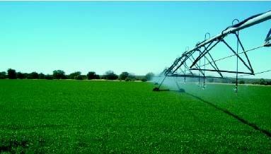
The northern part of this region is far more densely populated than the south, where the grazing is of poor quality and the water generally saline. This is predominantly an agricultural region in which mahangu is cultivated successfully. With intensive fertilisation and tilling of the soil, self-sufficiency should be attainable. A canal carries water from the Ruacana river to Oshakati, passing through Outapi. Water from this canal has been used to irrigate a large, government-run farm at Etunda where crops from maize to watermelon to bananas are grown. Non-agricultural employment opportunities will need to be created, however. The electrical network is expanding; while the rural areas may still lack electricity, towns including Outapi, Ruacana, Tsandi, Oshikuku, and Okahao all have electricity.
The region is traversed by a high standard trunk road which provides a direct link to adjacent regions and the rest of the country. Although passenger and freight transport along this route is easy, the rest of this road network, in common with all the communal areas of northern Namibia, is of poor quality. Okahao and Uutapi both have small hospitals, and a network of clinics provides basic services. The provision of schools is also inadequate and improvement in the position is expected.
In the north, Omusati borders the Cunene Province of Angola. Domestically, it borders the following regions:
Mr laban shapange director of education omusati region
Politics
The governor of Omusati is Erkki Endjala. The region comprises twelve constituencies:
Electorally, Omusati region is consistently dominated by the South West Africa People's Organization (SWAPO). For instance, Omusati voters selected SWAPO with 97.68% of their votes in the 2004 parliamentary election, and again with 98% in the 2014 election. The 2015 local and regional elections saw SWAPO win uncontested eight of the twelve Omusati constituencies, and two of the five towns. The remaining four constituencies SWAPO won by a landslide, with results ranging from 89% (Ruacana) to 98% (Ogongo).
Economy and infrastructure
Only 17% of households in Omusati have access to improved sanitation (toilet facilities). According to the 2012 Namibia Labour Force Survey, unemployment in the Region is 28.9%. Omusati has 274 schools with a total of 86,365 pupils.