
Post town SOLIHULL Dialling code 0121 | Sovereign state United Kingdom | |
 | ||
Population 12,167 (2011 CensusWard) | ||
Tudor court hotel
Olton is an area of the Metropolitan Borough of Solihull in the West Midlands, England. In the 13th century the Lords of the Manor moved their seat and formed a new settlement, in the junction of two major roads, that village has now grown into a big town called Solihull. It was then that Ulverlei was being referred to as 'Oulton' (meaning 'old town') to distinguish it from the 'new town' of Solihull of which it is now a part. It is located on the A41 between Solihull town centre 4 miles (6.4 km), Acocks Green, 2 miles (3.2 km) and Birmingham 5.7 miles (9.2 km), dating back over a 1,000 years, it is a now a residential suburb, though historically in Warwickshire. Many of the large houses built in St. Bernard's Road and Kineton Green Road during the Victorian and Edwardian period form part of one of Solihull's conservation areas.
Contents
- Tudor court hotel
- Map of Olton Solihull UK
- History
- Landmarks
- Governance
- Transport
- Education
- Religious sites
- Sports and leisure
- Notable people
- References
Map of Olton, Solihull, UK
History
Olton means 'old town' and is the site of the manor of Ulverlei from where Solihull was founded. Ulverlei has been translated to mean Wulfhere's clearing or meadow. Wulfhere was the first Christian king of all of Mercia, from the end of the 650s until 675. Wulfhere's father, Penda, was killed in 655 fighting against Oswiu of Northumbria. Penda's son Peada became king under Oswiu's overlordship, but was murdered a year later. Wulfhere came to the throne when Mercian nobles organised a revolt against Northumbrian rule in 658, and drove out Oswiu's governors. As he was a youth, Wulfhere had been kept in hiding until he came of age.
After the absorption of Mercia into the rest of England, Ulverlei became the property of the Earls of Mercia, who if not descendants of the royal house were their successors. The first of these was Leofric, husband of Godiva, heroine of the Coventry legend, and the earldom descended through his son Ælfgar to Edwin, his grandson, who was in possession at the time of the Norman conquest. Perhaps, because of the royal connection, William I granted the lands to Christina, who was descended from King Edmund Ironside.
The Domesday Book records Ulverlei as part of the lands of Christina, sister of Edgar the Ætheling, the last male of the house of Cerdic of Wessex, the original ruling dynasty of England. It states, "In Coleshill Hundred Christina holds 8 hides in Ulverlei from the King. Land for 20 ploughs. In lordship 1; 3 slaves. 22 villagers with a priest and 4 smallholders have 7 ploughs. Meadow, 12 acres; woodland 4 leagues long and 1/2 league wide; when exploited, value 12s. The value was £10; now £4. Earl Edwin held it."
Shortly after the Domesday Book was compiled in 1086, Christina "took the veil" entering the nunnery of Romsey Abbey in Hampshire. Her lands were granted to Ralph de Limesy whose family held Ulverlei until his great grand daughter married Hugh de Odingsells, whose family were thought to be of Flemish origin. William De Odingsells succeeded his father in 1238 and it was in his time that the new village of Solihull began to develop.
That Ulverley stood where Olton now does is evident from the survival of the place names of Ulverley Green and the Ulleries. Ulverley Green close to the Birmingham-Warwick Road is the probable site of the original Saxon manor house. The site was described by William Hutton
"Four miles from Birmingham on upon the Warwick Road, entering the parish of Solihull in Castle Lane, is Ulverley, in doomsday Ulverlei. Trifling as this place now seems it must have been the manor house of Solihull, under the Saxon heptarchy, but went to decay so long ago as the conquest. The manor was the property of the Earls of Mercia, but whether their residence is uncertain. The traces of a moat remain, which are triangular, and enclose a wretched farmhouse of no note; (named Manor House Farm) one of the angles of the moat is filled up and becomes part of Castle Lane, which proves that Ulverley went into disuse when Hogg's moat was erected; it also proves that the lane terminated here, which is about 200 yards from the turnpike road. The great width of the lane, from the road to Ulverley, and its singular narrowness from thence to Hogg's moat, is another proof of its antiquity. If we pursue our journey half a mile further along this lane which, by the way, is scarcely passable, it will bring us to Hogg's moat."
This site is now the Scheduled Ancient Monument of Hobs Moat, standing back from Lode Lane. The Hugford family occupied it after the Odingsells, Burman suggested that the name could as easily come from the Hugfords as the Odingsell's, as Hutton calls it Hoggs Moat in his 1782 description. However, Dugdale believed it derived from "Odingsells moat" and states he has seen Odingsells incorrectly written as "Hodingsells" and believes the corruption came from that. The Reverend Pemberton wrote that, "the moat, surmounted as it would have been by a stockade, would have been a formidable obstacle to assault" The Odingsells name is still to be found in the modern road name of Odensil Green built on the site of Odensil Farm.
Probably due to the relocation of the Lords of the Manor to the new settlement of Solihull, Olton declined in comparison and remained largely agricultural until the opening of the railway station in 1869 and the development of St Bernard's Road. Part of this road appears on the 1839 Tithe map and, in 1869, a new road was constructed to link this road with the Warwick Road. Originally named Windmill Road, it had become St Bernard's Road by 1872, named after the seminary that was being built then. The first house to be constructed in the road is thought to be Elmhurst (no. 21), which was used for a gathering of 200 people in 1872.
Landmarks
The Scheduled Monument of Hob's Moat, the derivation of its name is discussed above, is situated in Lode Lane, on the north-facing slope of a low hill and includes a moated site and the earthwork remains of a section of a hollow way. The moated site has external dimensions of approximately 137 metres north to south and 115 metres east to west. The steep sided moat ditches are dry and measure up to 7 metres wide and 2.5 metres deep. External banks are visible on all four sides of the moated site and although the northern and eastern banks have been lowered they can be traced on the ground surface. The banks are approximately 12 metres wide at their base and have an average height of 1.8 metres. The moated island is 0.65 hectares in area and slopes gradually from south to north. There is an internal enclosure bank on the west, north and east sides of the island, running parallel to the moat ditches. An excavation across a section of the inner bank in 1985 provided evidence for the bank's construction; deposits of stony clay mounded up over a sandy gravel core. A second bank was located beneath the inner one which consists of a sandy bank revetted on either side by bands of cobbles set in clay. This feature is earlier in date than the inner bank and employs a different construction technique. An excavation in the southern half of the moated island has indicated that the structures which originally occupied the island will survive as buried features. The remains of a small structure, bounded by walls set within shallow foundation slots, were located. Excavations within the moat have recovered evidence for a collapsed sandstone wall, and suggested a late 13th century date for its construction. The remains of the wall had been overlain by the base of a later structure. Immediately alongside the north side of Hob's Moat are the earthwork remains of a hollow way which is medieval in origin. Excavation, geophysical and field survey carried out between 1985–86 revealed pottery found in a trench excavated across the inner rampart and interior indicating a 13th-century construction date, with later modifications to the enclosing earthworks. The remains of a number of medieval buildings were found, and in addition a late medieval/early post medieval shed-like structure. The activity on the site during the 17th century and later appears to be agricultural. A survey carried out in October 1997 by RCHME concluded that he site was probably a homestead or hunting lodge.
Governance
Politically, the Olton ward has recently leaned towards liberalism. Since 1973, the three seats on Solihull Council have been shared by Conservative and Liberal (later, Liberal Democrat) councillors. Honor Cox of the Liberal Democrats held the ward from 1991 until her death on 1 November 2010. However, for several years now all three seats have been held by the Liberal Democrats. Olton has a strong residents' association that liaises with Solihull Council and other bodies to improve the locality.
Nationally, Olton is a ward of the Solihull constituency whose Member of Parliament is Julian Knight, (Conservative), who replaced Lorely Burt, the first Liberal Democrat MP for Solihull, at the 2015 election.[1] Olton is included in the West Midlands electoral region of the European Parliament, the seven members elected in 2014 are; Philip Bradbourn OBE, (who died in December 2014) and Anthea McIntryre (Conservative), Neena Gill and Sion Simon (Labour) and Jim Carver, Bill Etheridge and Jill Seymour (UK Independence).
Transport
Education
Religious sites
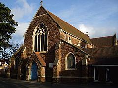
Situated at the junction of the Warwick Road with St Bernards Road and Kineton Green Road is the parish church of St. Margaret's, begun in 1880 as a chancel and completed by B. Corser in 1896. It has rock faced walls, no tower and round piers with well carved naturalistic flower capitals.
To the south is the Roman Catholic Olton Friary. Built in 1873 as St Bernard's Catholic Seminary by Bishop William Bernard Ullathorne, the first Catholic bishop of Birmingham, it closed in 1889 when the bishop's successor moved the seminary to Oscott. The building was purchased by the Capuchin Friars and became the Franciscan Monastery of the Immaculate Conception. The friars left on 10 January 1981 and the Sacred Heart Fathers and Brothers of Bétharram took over the running of the parish.
There are also the United Reformed church on Kineton Green Road and Olton Baptist Church, which meets at Langley School on Kineton Green Road.
On the Warwick Road just by the railway bridge is the former Primitive Methodist Chapel which appears on early 20th century maps: the building is now a bridal shop.
Located on Monastery Road the Solihull and District Hebrew Congregation hold regular religious services at their Solihull Synagogue as well as running a wide range of social activities.