
Population 2,853 (2011 census) Sovereign state United Kingdom Local time Thursday 3:48 PM | OS grid reference SP2890 | |
 | ||
Weather 10°C, Wind NE at 31 km/h, 58% Humidity | ||
Old Arley is a village in the north of Warwickshire, England 10.5 miles (16.9 km) north west of the city of Coventry. Population details from the 2011 Census can be found in Arley
Contents
- Map of Old Arley Coventry UK
- Location
- Closest towns and transport
- History
- 1848 1891
- 1900
- Arley Colliery
- Daw Mill Kingsbury and Dexter Collieries
- Demography
- Industries of Work
- Nationality
- Economic Status
- Churches
- References
Map of Old Arley, Coventry, UK
Location
The village is within the civil parish of Arley in the North Warwickshire district of Warwickshire of which it is the less populated settlement. It is to the west of the stream called Bourne Brook and the Birmingham to Peterborough railway line. The other settlement within the parish is New Arley which is south-east.
Elevations of developed estates range from a maximum of 153-155m AOD in the Devitts Green western part of the village, gently down to 112m at the southernmost neighbourhood, which adjoins the brook itself, which by the time it reaches the western tip of the parish at the defunct Daw Mill colliery, is at 92m AOD. The locality of New Arley known as Hill Top is higher still at 166m, the highest point of the parish.
Closest towns and transport
The village and parish is 10.5 miles (16.9 km) north west of the city of Coventry, and 6.8 miles (10.9 km) west of the town of Nuneaton but with equally good connections to Coleshill and to Birmingham, particularly its airport/NEC area.
The nearest railway station is at Atherstone railway station which is 4.8 miles (7.7 km) north east of the village.
The B4114 runs along gentle hillsides east-west to the north of the village and travels west 4 miles (6.4 km) to meet the motorway network by the village of Coleshill on the nearside of Spaghetti Junction providing there a direct route over that junction to Birmingham or a short stretch (of the A446) south to Junction 4 of the M6 for longer distance journeys.
History
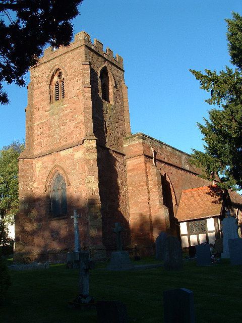
Old Arley is included in the Domesday Book which was compiled in 1086. In its entry there the village, which is named as Arei, has four households, 2 men's plough teams, Woodland of 1.5 by 1 leagues. In 1066 the lord of the manor was Earl Edwin, and in 1086 the lord of the manor was Princess Christina who was also listed as the Tenant-in-chief. The parish had a taxable value of 1 geld unit per year. The village and parish was foremost a farming community and had several hamlets within its parish which combined slowly into the village of Old Arley: Gun Hill, Slowley Hill, Devitt's Green and Ballard's Green. The village was centred on the gothic, stone-built parish church of Saint Wilfrid.
1848-1891
Samuel Lewis described the village in 1848:
ARLEY (St. Wilfrid), a parish, in the union of Nuneaton...hundred of Knightlow, N. division of the county of Warwick, 8 miles (N. N. W.) from Coventry; containing 265 inhabitants. The parish is traversed by the road from Coventry to Tamworth, and comprises 1929a. 29p. of land, the greater portion of which is pasture and meadow; 140 acres are wood, and 20 common or waste. The soil is variable, some parts good, and some stiff clay; the surface is undulated, and the scenery picturesque. lime in considerable quantities, and stone for the roads, are obtained here. The chief proprietor is Alfred Ashley Vaughton, Esq., of Fillongley Lodge. The living is a rectory, valued in the king's books at £9. 0. 7½.; patron and incumbent, the Rev. R. R. Vaughton: the tithes have been commuted for £336. 8., and the glebe consists of 74 acres. The church is an ancient edifice, with a square tower. £20 yearly out of lands producing upwards of £200 per annum, left by William Avery, and a donation of the interest of £600 in the new three-and-a-half per cents, by John and Francis Holmes, go towards the support of a free school. A Sunday school is supported by the rector.
In 1881 the population of the village was 207 and by 1891 it had risen to 216.
1900
In 1900 the Kelly’s Directory includes a Post Office, with a post box built into the wall, which was said to be by the church. There was also a mixed free school which had been opened in 1875 for an attendance of a capacity of sixty, but had an only an average attendance of thirty-three pupils. There was also a railway station with station master Alfred Lingdon. Kelly's also lists a total of twenty farms, one mill and one public house, the Wagon Load of Lime. There was also one shop.
Arley Colliery
The village once had an eponymous colliery running beneath part of its central area which employed 1,734 men when it was finally closed on 30 March 1968, by the National Coal Board. It had then been in operation for sixty six years and had once been owned and operated by the Arley Colliery Company Ltd. Production began at the pit on 1 January 1901 and the first coal was extracted from the mine in 1902. The mine was considered no longer economically viable by the NCB led by Lord Robens, officially of the Labour Party, in 1968, due to its relatively high costs and despite the cited fact that one hundred years of coal remained beneath. As production increased the colliery expanded and with this the population within the parish increased. This led to a need for new housing in the area. Between 1920 and 1955 six hundred houses were built on land which had been the Fir Tree Farm, this became New Arley.
Daw Mill, Kingsbury and Dexter Collieries
The two shafts that served Daw Mill were first sunk between 1956 and 1959, and 1969 and 1971 respectively. Daw Mill was a natural extension of the former collieries, Kingsbury Colliery and Dexter Colliery. On 7 March 2013 the owner, UK Coal, announced the Daw Mill mine towards the edge of the parish would be closed following a major fire - it was the last remaining colliery in the West Midlands.
Demography
The usual number of residents in the civil parish which includes the slightly larger village of New Arley, was 2,853.
Industries of Work
The working population worked as set out below in the official industry categorisations in 2011:
Nationality
The ward is relatively representative of the nation as a whole in terms of national identity:
Economic Status
The proportions of those retired, unemployed and who were students in 2011 were extremely close to the national averages, with a slightly higher degree of the retired and lower degree of students, whereas those in the economically inactive (other) category were fewer:
Those who replied that there were no people in the household with English as their main language formed a proportion of the population 3.6% lower than the national average.
Churches
The parish church of Old Arley is called Saint Wilfred and there is a Methodist church in the village.