Girish Mahajan (Editor)

Ojstrica

Updated on
Edit
Like
Comment
Share on FacebookTweet on TwitterShare on LinkedInShare on Reddit
Mountain type
  
limestone

Elevation
  
2,350 m

Parent range
  
Kamnik–Savinja Alps

Easiest route
  
South

Age of rock
  
250.16589 million years

Mountain range
  
Alps, Kamnik–Savinja Alps

Ojstrica httpsuploadwikimediaorgwikipediacommonsthu

First ascent
  
1823 by Ernest Joanelli

Similar
  
Planjava, Grintovec, Raduha, Brana, Skuta

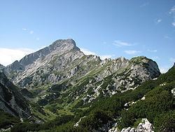
Ojstrica (2350 m) is a mountain in the eastern part of the Kamnik Alps With its pyramide shaped top, it is visible from far away. The name Ojstrica derives from slovene word ostro - sharp in slovenian language. There is a 600 meter deep wall on its northern side to the bottom of Logarska Dolina. The eastern side, down to Robanov Kot, also has a deep wall. There are several climbing routes available.

Contents

Map of Ojstrica, 1242 Stahovica, Slovenia

Starting pointsEdit

  • Kamnik, Kamniška Bistrica (601 m)
  • Solčava, Logarska dolina (761 m)
  • Solčava, Robanov kot (ca. 700 m)
  • RoutesEdit

  • 1½h: from Kocbekov dom na Korošici hut]] (1808 m), on the southern side
  • 1½h: from Kocbekovega doma na Korošici]] hut (1808 m), on the eastern side
  • 4h: from Koča na Kamniškem sedlu (1864 m), under Planjava over Škarje
  • 3½h: from Koča na Klemenči jami pod Ojstrico hut (1208 m), over Škarje
  • 3h: from Koča na Klemenči jami pod Ojstrico hut (1208 m), over Škrbina
  • References

    Ojstrica Wikipedia